

Egypt geology
Egypt geology is a land of contrasts – the fertile Nile Valley, the arid desert regions, the lowland Sahara and the highland Red Sea Hills.
In spite of their apparent desolation, the deserts have frequently played an important part in Egyptian economic life.
At the end of the Pleistocene, as the glaciers began to retreat, post-glacial global warming provided more humid periods in Egypt from around 10,000bp to around 3500bp.
The deserts were more like the Sahel or savannah areas, with ephemeral water supplies and grass/shrub vegetation offering resources for animals
and humans to exploit. Even after the increasing aridification at the end of the mid Holocene, the deserts continued to be exploited during moister periods.
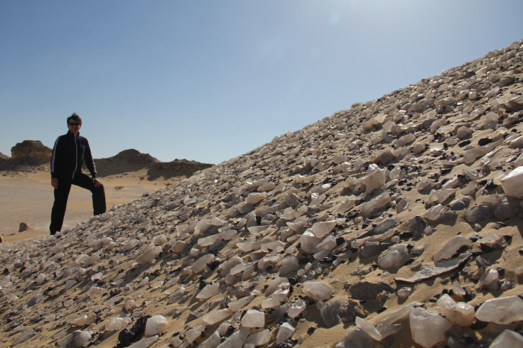
In the Western Desert a semi-circle of oases offered refugia to those driven out of the desert, and in the Eastern Desert natural stone and mineral resources continued to attract quarrying and mining expeditions and settlements.
Nomads have continued to occupy the Eastern Desert
up until modern times, surviving on the sparse opportunities offered by sporadic orographic rainfall attracted by the Red Sea mountains. The Eastern Desert extends from the eastern edges of the Nile Delta down into the Sudan, between the Nile and the Red Sea.
It measures c.1100km from north to south, and 225km (on average) from east to west, an area of over 222,000sq. km (Morrow and Morrow 2002, p.11).
It forms around 22% of Egypt’s surface area, but is undeveloped due to the limited availability of water (Moneim 2005, p.416).
The wadis that bisect the mountains and the plateau of the Eastern Desert provided natural routes which have been used at different times by hunters, pastoral nomads, caravans, military personnel and industrial work teams (ancient and modern) and tourists.
Most wadis are orientated east to west (e.g. Wadi Hammamat), but some head broadly south to north (e.g. Wadi Qena).
The best known of the east-west wadis is the Wadi Hammamat.
This extends from Qift (ancient Coptos) in the east to Quesir on the Red Sea coast in the west.
It was paved in modern times, which has made it one of the most popular east-west routes.
Prior to the paving of the Wadi Hammamat, the Wadi Qash to the south was also a well used route used for traveling between Quseir and Qift, but via Bir Kareim, Bir Qash and Laqeita (where the Wadi Qash route and Wadi Hammamat meet).
To the north, the Wadi Araba connects the Nile, just south of the Faiyum, to the Red Sea.
A good infrastructure of roads was required to support both industrial activities and trade with coastal areas.
Many of these routes are no longer visible and their presence cannot be detected, although contemporary documentation confirms their existence, and the existence of others is implicit simply because of the need to connect certain key sites.
Other routes are still active and important today.
The route provided by the Wadi Hammamat was of major importance, providing acess both to the Red Sea and to the quarries along the Wadi Hammamat itself.
The Wadi Hammamat route
in fact also incorporates the Wadi Atulla and Wadi Gasus.
During the Ptolemic Period, sea trade with with Arabia and Asia raised the importance of many of these routes.
As new harbours were built, more roads were cleared to connect important towns and ports, via wells and other water sources.
The Eastern Desert is still occupied today by a dwindling number of Bedouins, made up of a number of different groups, with different subsistence strategies including both sedentary and nomadic ways of life.
Many are now moving to more modern ways of making a living, finding employment in tourism and industry.
Today, the Eastern Desert and the Red Sea Coast are popular among tourists for principally three reasons.
The least of these is probably the various inscriptions from the Predynastic and Dynastic Periods, along with the Roman forts, hydreuma, way stations and the few obscure temple ruins that dot the landscape.
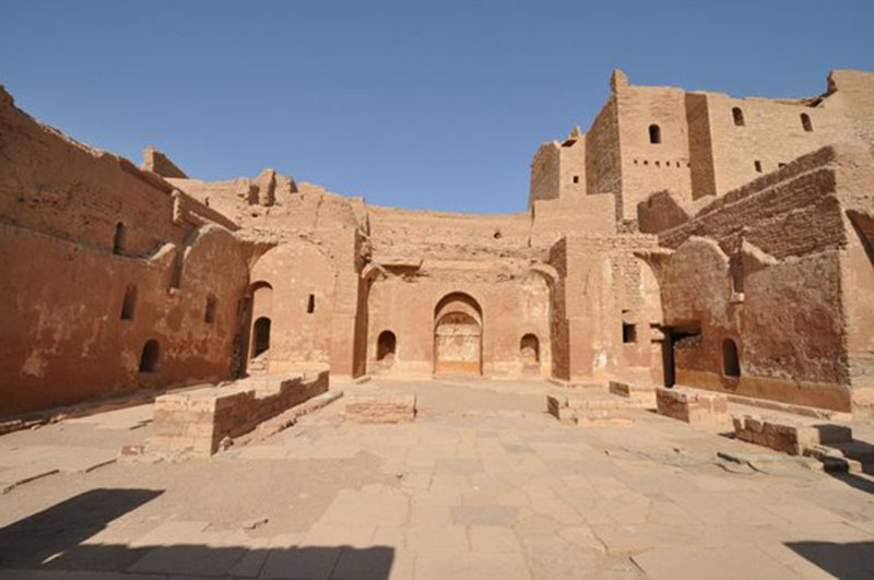
More popular, and becoming more accessible to tourists, are the several Eastern Desert monasteries of St. Anthony and St. Paul. These have seen much interest of late.
However, the most popular destination for tourists have little to do with Egypt geology history. They are the Red Sea resorts, of which Hurghada is best known.
Other popular coastal resorts are upscale el-Gouna, and of late.
Along the coast, there are other smaller resort communities, many specializing in scuba diving activities.
Egypt geology The Modern Environment
Today, the average rainfall received by the Eastern Desert annually ranges between 2.75 and >50mm annually (Monein 2005, p.417).
The higher figure is recorded only in the southeastern zones.
The Eastern Desert receives more rainfall than the Western Desert, which is due largely to the relief of the Eastern Desert , where the Red Sea hills attract orographic rainfall (Davis 1953, p.158). However, at Quesir on the Red Sea coast where the mean temperature is 28 degrees centigrade, annual rainfall is only around 4mm (Moeyersons et al 1996), whilst at Hurghada on the Red Sea coast it is nearer to 3mm (Hobbs 1989, p.4).
Occasional rainfall often takes the form of short and quite violent storms which result in large volumes of water racing down the wadis from the Red Sea mountains to the Nile or to the Red Sea.
In 1954 a freak storm caused the dry Wadi Qena to fill, and the resulting flooding caused damage in the town of Qena at its Nile end (Hobbs 1989, p.4). Monein (2005, p.417) observes that “even though the amount of rainfall is quite small, floods are the major natural hazard in the Eastern Desert” and that in the last 50 years flash floods have been recorded in the years 1969, 1980, 1984, 1985 and 1994.
Harrell et al (2000 p.35) record that the area of manzal el-seyl, where the Early Dynastic Gebel Manal el-Seyl stone quarry is located, translates to ‘the place where the flash floods (seyl) divide (manzal) and that this “apparently alludes to the tendency of flood waters from Wadi Mellaha Umm Barmil to split and flow around the ridge.” Maximum and minimum recorded temperatures “are 41 degrees C and 21 degrees C respectively and increase from north to south, while the relative humidity (RH) ranges between 56% and 30%, averaging about 43% in summer and 48% in winter” (Monein 2005, p.417). There are very few springs or wells today and these are “barely enough to supply scattered populations” (Monein 2005, p.417).
The modern towns along the Red Sea Coast, which are becoming increasingly important for tourism and are growing at a staggering rate, receive their water from the Nile through canals and pipelines or from sea water processed through desalinization plants (Monein 2005, p.417). Groundwater accounts for very little of the water consumed by human populations in and on the edges of the Eastern Desert. Goodman and Hobbs (1988) describe the vegetation of the Egyptian desert as follows: “Vast portions of the region are devoid of any plant cover, particularly in the north. The higher plant concentrations tend to be in wadi bottoms, on shaded mountain slopes, and in deep canyons.
As one moves from north to south there is a notable increase in both the quantity and spacial distribution, and regularity of precipitation (p.76). They say that most of the Eastern Desert plants belong to the Saharao-Sindian phytogeographical region (p.76). In the desert itself, patchy and unpredictable rainfall forms temporary pools and watercourses, and the land briefly comes to life with vegetation: “This phenomenon of brief, localized rainfall, followed by profuse but spotty and short-lived plant growth, provides the basis for Bedouin life.
Some of the water is absorbed into the ground and becomes groundwater, into which wells have been sunk since the Pharaonic period, some of which are still in use.
The modern Bedouin rely mainly on rainfall for their survival, with few wells and fewer springs.
Drip-water pools from cliff run-off is very highly regarded but uncommon.
Rain-fed rock basins are important, and my last weeks or even years, but are used sparingly to preserve an important resource (Hobbs 1989, p.47-48). Winters are mild and dry but may be cold at night, whilst summers are very hot and arid.
At certain times of the year frost and snow may occur when clouds hang over the mountains (Hobbs 1989, p.2) Peter Cherry’s overview of the fauna of the Eastern Desert (2002a p.187-191) details those wild animals which survive today, in spite of the aridity.
They include feral camels, cape hare, Dorcas gazelle, lizard, Nubian ibex and a number of birds. The birds include brown necked raven, houbara bustard (Chlamydotis undulata) and partridge (Ammoperdix heyi), spotted sand grouse (Pterocles senegallus), coronetted sandgrouse (Pterocles coronatus) desert lark, white crowned black wheatear and, although very rare indeed, ostrich (Hobbs 1989, p.91; Cherry 2002a, p.187-191).
Rock hyrax (Procavia capensis) is also present and is considered very important to the Ma’aza Bedouin (Hobbs 1989 p.88).
Less popular are snakes, spiders and scorpions, all of which can bite or sting (Hobbs 1989, p.62). Ostriches in Egypt were the subject of a paper by Nicolas Manilus (2002, p.945-953), who plots the presence of the ostrich in Egypt throughout both prehistoric and historic periods.
He concludes that the ostrich, which declined consistently since its abundant presence in the past “disappeared from the north of the country and lived only in the southeast up to the end of the nineteenth century” (Manilus 2002, p.945).
A brief revival in its fortunes between the 1960s and the early 1990s was probably the result of escapees from ostrich farms.
Due to the albeit occasional rainfall, “The Eastern Desert has a much richer flora than the Western Desert, due to its greater relief, heavier rainfall, and the larger variety of suitable habitats.
The richest communities are those of the first terrace in deep limestone valleys, and those of hills covered with flinty gravel imbedded in a sandy matrix. Most of the desert associations must be classed as edaphic or biotic climax communities” (Davis 1953, p.172).
Hobbs’s overview of the plant life that survives the arid conditions of the Ma’aza Bedouin territory include desert-adapted perennial shrubs and small trees including Acacias, Zizyphus spina-Christi, Tamarix, Solenostemma arghel, Hyoscyamus boveanus, wormwood, Ben-tree (Moringa peregrina) and Salvadora persica.
(Hobbs 1989, p.40, p.97). Wormwood is widespread in both limestone and granite regions of the Eastern Desert, Ben tree grows only on lower flanks of high mountains which catch sufficient moisture to feed the tree, argel is quite rare.
Other vegetation springs into life when rainfall saturates the desert wadi floors, providing areas where small plots can be cultivated and herds can be pastured.
Modern occupants of the Red Sea Mountains and the desert areas include the Bedouins, of whom there are around 1000, approximately one person per 50 square miles or 90 kilometers (Hobbs 1989, p.2).
The Bedouins are made up of a number of different groups, and are not confined to Egypt, Nubia and Sinai.
The Ma’aza Bedouin grow barley, millet, maize, melons and other crops in plots which are supplied with water once a year by storm floodwaters which flows down the wadis dissecting the Red Sea hills (Hobbs 1989).
In modern times, the environment has been considerably modified by human intervention.
As well as the addition of formal roads where vehicles can travel, native Bedouin have removed acacia and tamarix and over-hunted barbary sheep to the point of local extinction. Game hunters have also helped to deplete the population of gazelle.
Larger wild animals are now rare.
The rainfalls are unpredictable in terms of where they will fall and how much water will be deposited, so nomads of the desert have to be mobile and flexible in their approach to division of labour, and co-operative use of tribal territories (Hobbs 1989). In a comparison of plant use by the Beja Bishcharin and Ma’aza Kushmaan nomads of the Eastern Desert, Goodman and Hobbs (1988) found that 21 species were used by the clans, for nutritional, medicinal and utilitarian purposes.
All 12 species used for food were common to both the Bishcharin and Kushmaan, and there are very close parallels with uses of plants for medicinal and utilitarian purposes.
Few plants were used in different or opposing ways (1988, p.86). Interestingly, Goodman and Hobbs conclude that the data analyzed suggests that the utilization of the plants by the two groups was independently developed.
Although the groups may have had contact, they are culturally very distinct (the Bisharin of Hamitic origin, the Kushmaan from northern Arabia) and there are few indications from language or tradition of much overlap between the two.
Today’s northern limit of Afrotropical vegetation is at Gebel Elba in the Bischarin territory (Goodman and Hobbs 1988).

In an analysis of the northern Eastern Desert’s ecological makeup Dargie and El Demerdash (1991, p.9) indicate that disturbance (grazing and woodfuel collection) and moisture status have had a considerable impact on the local environment, with water availability being heavily influenced by wadi materials and both are probably more accountable for biomass and species differences in some regions than the distinction between limestone and sandstone rock types alone proposed by some earlier writers.
Disturbance has had particularly high impact where major areas of settlement and new roads provide access to resources.
Egypt geology Prehistoric and Historic Periods
Gerald Fuchs has highlighted the lack of work that has been done on determining past environment in the Eastern Desert, when compared with work that has been carried out in the Western Desert: “Scientific research in the region of the Eastern Desert (Palaeobotany, Archaeozoology, Geomorphology etc) is still missing completely” (1991, p.70).
Things have improved only slightly in the intervening years. Work done in the last 10 years or so by the Belgian Middle Egypt Prehistoric Project have helped to elucidate environmental conditions at a number of sites in the Eastern Desert/Red Sea area, but the low levels of survey and excavation in the Eastern Desert (other than rock art research), have left the environmental situation of past times somewhat unclear (Majer 1992).
The work by Moeyersons et al (2002) at the Sodmein Cave in the Red Sea Mountains,
35-40km to the NNW of Quseir, has provided some data about environmental/ecological conditions in this area at different times. However, an important lesson from studies into climate and environment across the Sahara has been that although general regional sequences may be identified, local conditions may vary enormously according to different topographical and ecological conditions: “it cannot be assumed that fluctuations in neighbouring areas were necessarily contemporaneous (Phillipson 2005, p.173).
The Sodmein Cave is in a wadi of the Red Sea Mountains, where there is greater rainfall than, for example, the plateaus of the Eastern Desert proper.
A number of periods of climatic dry and humid phases have been identified, some of which have been tied into the archaeological data from the cave.
This information is captured in the following table, compiled from data presented by Moeyersons et al (2002). The terms humid and wet used in the table below “point to the relative idea of wetter conditions than the present-day hyperarid ones” (Moeyersons 2002, p.849) and do not necessarily indicate wet periods as we understand them.
The fact that some wet periods identified in other areas like the Western Desert are not represented here (for example a wet phase in the Eastern Sahara at 90,000 BP) may mean either that the data from Sodmein represents a localized environment not typical of the entire region, or it may imply that data is missing.
It is also possible that the data captured here represents bigger and more obvious environmental occurrences, whilst not isolating fluctuations within overall trends.
Date
Climate
Environmental Data
Archaeological Data
125-130,000BP
Warmer more humid phase, coinciding with the Eemian Interglacial
It is suggested that a precipitation of c.600mm per year (wet conditions) would be conceivable in the Sodmein area (p.847)
115,000 BP
Istotopic Stage 5e.
Rainstorms resulted in permanent pools and swamps, and other water bodies, indicated by the presence of crocodile, Clarias and Melanoides tuberculata. Moeyersons et al also suggest that the area may have been linked to the Nile on an intermittent basis (p.849-50)
Plants include Acacia, clematis, grasses, and Ficus Sp. (Moraceae)
Big savannah fauna include bovids, kudu, elephantid and flies (Chrondmidae)
Sodmein Cave’s J-Complex (Middle Palaeolithic). Apparently corresponds to the same wet period at Bir Tarfawi in the EAstern Desert.
Unknown, but between 115k and 25k BP
Wet periods
Middle Palaeolithic Level 4 C14 dated to older than 45000 BP
Middle Palaeolithic Level 2 at 29,950+/-900 and 30>/- 30,000BP
25,000 BP
(25,200+/-500)
Wetter conditions at or around this time, corresponding with a wetter period elsewhere in Africa including the Nile Valley (Paulissen and Vermeersch 1987)
Upper Palaeolithic Level 2, and perhaps Level 1 (Van Peer et al 1996).
Unknown, but betweeen 25000bp and c.8000bp
This can be represented by layers D, F. G and I at Sodmein.
A mixture of species indicate desert or semi-arid and dry sparsely wooded savannas.
Faunal remains include Capra ibex, barbary sheep, wild ass, Soemmering’s gazelle, greater kudu, vervet monkey, hunting dog, seval or caracal and leopard.
Several woods are represented in the dark (organic) layer of Layer D.
Whitish layers may be indicative of environmental degradation and drier but not hyper-arid conditions
Time gap between base of Layer C and top of Layer D coincides with LGM.
c.8000 – 6000 BP
(6320 – 7470 BP)
Following the LGM. C-Layer (whitish) followed by B layer which appears to correspond to Early Holocene “wet Interglacial”. Sparse rains are indicated, and the presence of an oasis is a possibility. Conditions were wetter than today but without exotic elements typical of much more humid conditions elsewhere.
Conditions were still somewhat arid. Conditions were apparently similar to those at Tree Shelter, 1 km away.
Ten tree species are represented, dominated by Acacia cfr Tartilis (Forsk.) Hayne and Tamarix sp.
Fauna includes present day species plu Dorcas gazelle, Rock dassie, domesticated sheep and goat, rodents and various insects including the specie Hymenoptera
Suggested an average of about two rains per “rainy season” based on C layers (p.850).
Layers C (whitish) and B (highly organic)
Layer B is Neolithic and contains large numbers of domesticated ovicaprines associated with lithics and (top section only) ceramics
The period between 25,000 and 8000 bp in the above table lacks details. Some idea of what sort of conditions might have been experienced in Egypt at this time are covered in an article looking at the Earlier Holocene of the Nile Valley by Vermeersch (2002, p.31).
Vermeersch suggests that the period immediately prior to 12,000 BP known as the Wild Nile phase was accompanied by a hyperarid climate.
Occupation of Egypt during the Wild Nile phase is attested to at a small number of sites on the desert margins.
After the Wild Nile phase a lowering of the Nile’s floods began,
perhaps becoming so low that the Faiyum lake lost access to the Nile and may have dried up for around 500 years at c.10,000 BP, and then became high between 9500 and 8000 BP – attested to at Elkab and Armant (Vermeersch 2002, p.32). Another dry phase appears to have followed from 8000 to 7200 BP when the Faiyum dried again, but the Nile appears to have experienced high floods in Bubia at around 7200BP, when the Faiyum lake again refilled.
Dittman (1993, p.149) says that at one point during the Middle Palaeolithic samples of sinter indicated that spring-fed open water surfaces were available at least between radiocarbon years 26,350 and 26,900 BC, but it is not clear when this humid period actually began or ended.
After the Middle Palaeolithic “the drying-up of the region truly took the character of an ecological catastrophe: the protective vegetation cover disappeared, the loose deposits fell victim to erosion and their deposition took place within the upper and middle sections of the drainage systems”. Dittman summarizes the data for the later prehistory of the northern part of the Eastern Desert in Egypt as follows (1993, p.152):
Time
climatic Conditions
Geomorpho-Dynamic Processes
Human Culture
Recent to proto-historic
Arid
Episodical wadi floods (one event during 5-6 years)
Exrosion at the margin of lder sediments
Rock Egnravings
4000 – 2000 BC
Semi Arid
Periodical wadi floods
No important transformation processes
Neolithic occupation (hutning, stock breeding sheep and goat)
After 20,000 BP?
Arid
Episodical wadi floods
?
After 26,000 BP
Arid
Episodical wadi floods
Erosion on the slopes and accumulation of the Main Wadi Sediments int he upper and middle sections fo the wadi
?
About 26,000 BP
Semi arid tosemi humid
Longer, periodical wadi floods
Open water surfaces and development of sinter
No important geomorphic transformation processes
?
Before 26,000 BP
? (Semi Arid)
Dissecrtion of the wadi’s third section of pediment gravels
Middle Palaeolithic occupation
Toby Wilkinson, looking at the Eastern Desert as a whole, has highlighted the surprising amount of vegetation that survives today in some wadis, and suggests that “it would seem likely that a small increase in average rainfall would be sufficient to turn this semi-desert back into savannah” (p.158).
A comparison of plant use by the Beja Bishcharin and Ma’aza Kushmaan nomads of the Eastern Desert by Goodman and Hobbs (1988) found that 21 species were used by the clans, for nutritional, medicinal and utilitarian purposes.
This provides an indication of the amount of plants are available in the Eastern Desert for food (12 species), and suggests that in past times with only a slight increase in humidity, both the number of species and the density of the vegetation could have been significantly greater.
The following map, copied from Krzyzaniak 1977 (who in turn modified it from Butzer) shows the main ecological zones of the Eastern Desert between 5000 and 3000BC:
The map implies that between 5000 and 3000 BC the Eastern Desert would have had areas which would have been very attractive for pasture, with a maximum rainfall of around 150mm.
There is one single specimen of Maerua crassifolia known from the Ma’aza’s tribal area, together with isolated examples of wild olive, white saksaul, white acacia, Indian mastiche, all of which are thought to be the last remains of the woodlands of the desert environment as it was between c.3000 and 7000BC (Hobbs 1989, p.97).
I have added the Western Desert sequence for the Neolithic below for comparative purposes, and because it has detail that shows climatic trends which were taking place in the Eastern Sahara.
It must be emphasized that local topographic conditions will have accounted for considerable variations – there is a vast difference between the rainfall conditions likely to be attracted by the highland areas of the Red Sea Hills and that by the largely un-differentiated areas of the desert zones in the Western Desert. From Wendorf and Schild 2002:
The Post-Al Jerar Arid Phase, c.7300-7200bp is marked by massive deflation at Napta Playa, high winds and heavy sandstorms.
The Middle Neolithic Humid Interphase, c.7200-6600bp
showed signs of local rains but no lacustrine deposits.
Human occupation is attested to at E-75-8. A Post Middle Neolithic Arid Phase, c.6600-6550bp is marked by deflation and aeolian erosion.
This is followed by the Late Neolithic Interphase, c.6550-5800bp: “a perched water table in the deflational basin at site E-75-8 is indicated by consecutive wells in the centre” (p.24). Another deflational stage is called the Post Late Neolithic Arid Phase and dates c.5800-5500bp.
It is generally agreed that the climate of the area today was only a little more humid than during pharaonic times. The Eastern Desert began to dry out during the same period that civilization took hold in the Nile Valley.
Egypt geology
As James Harrell points out in the opening comments of his paper Stone in Ancient Egypt (Harrell WR/d) “Much of what remains of ancient Egypt consists of stone.
There are building stones for temples, pyramids, and tombs; ornamental stones for vessels, sarcophagi, shrines, stelae, statues, and other sculptures; gemstones for jewelry; and utilitarian stones for tools, weapons, pigments, and other applications.
Still other stones were processed to extract their precious metals.
These remains range in age from the Late Predynastic period (beginning about 3200 BC) to the Roman period.” The geology of Egypt has defined the character of its architecture and material remains.
The following text is derived, unless otherwise stated, from Bonnie Sampsell’s excellent A Travellers Guide to the Geology of Egypt (2003, p.154-183). For a full description of the geology of this (and other) areas of Egypt, I recommend her very well written book, available from the American University in Cairo Press, and various online book sellers. An excellent online resource is James Harrell’s Eastern Desert geology site at
The Basement Complex was laid down from the Pre-Cambrian age.
By the end of the Eocene, around 37 million years ago, the rock layers known as the Basement Complex covered Egypt.
This is made up of igneous and metamorphic rock from the Pre-Cambrian age, and Nubian sandstone from the Lower Cretaceous, Cretaceous limestones and shales and Eocene limestones. At this time the landscape was relatively featureless in terms of geomorphology and topography (Sampsell 2003).
The plutonic igneous and metamorphic rocks which form the Red Sea mountains and hills are over 550 million years old.
Basement Complex rocks of sedimentary and volcanic igneous origins are mostly less than 100 million years old (Harrell WR-f) The plutonic igneous and metamorphic rocks which form the Read Sea mountains and hills are over 550 million years old.
Basement complex rocks of sedimentary and volcanic igneous origins are usually less than 100 million years old (Harrell WR/f).
Eon
Era
Period
Epoch
Beginning (Years ago)
Phanerozoic
Cenozoic
Quaternary
Holocene
10,000
Pleistocene
2 million
Tertiary
Pliocene
5.1 million
Miocene
24.6 million
Oligocene
38 million
Eocene
55 million
Paleocene
65 million
Mesozoic
Cretaceous
144 million
Jurassic
213 million
Triassic
248 million
Paleozoic
Permian
286 million
Carboinferous
360 million
Devonian
408 million
Silurian
438 million
Ordovician
505 million
Cambrian
590 million
Precambrian
c. 4600 million
Table copied from Sampsell 2003
The Pre-Cambrian rocks, some of which are exposed in the Red Sea Mountains include gabbroid, granite, serpentines, volcanic and geosynclinal metasediments and metavolcanics (Monein 2005, p.421)
Following the Eocene, it is believed that the mechanisms of plate tectonics divided the Arabian Peninsula from the African Plate, creating the Red Sea.
This process began in the Oligocene but probably continued throughout the Miocene and Pliocene. As part of this rifting process, rock layers to the west of the Red Sea were uplifted to form the Red Sea Mountains, with similar formations developing in Saudi Arabia.
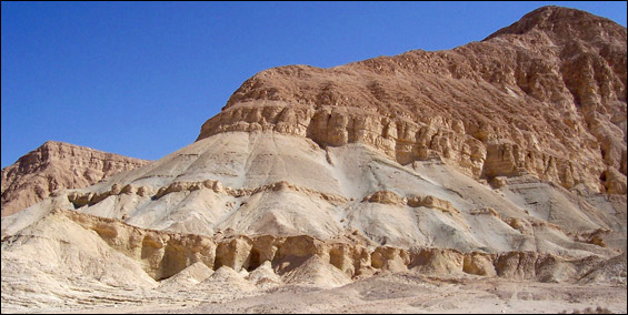
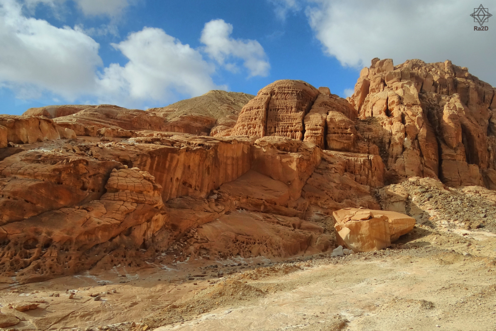
Today these mountains reach heights of nearly 3000m, but may have been much higher when formed, attracting orographic rainfall, which etched channels into the mountains and eroded rock layers, removing the vulnerable limestones and sandstones and leaving behind the more durable igneous and metamorphic rocks of the uplifted basement layer. Today, the maximum elevation is in Gebel Shayeb el-Banat at 2187m.
Elevations are lower in the north where rock foundations are mostly of Tertiary and Mesozoic age (Ibrahim and Ibrahim 2003, p.60).
The high limestone plateaus of the Eastern Desert were formed in the Miocene and Eocene (Monein 2005, p.419).
During the Pleistocene alluvial deposits were laid down.
Today the Eocene limestone can be seen in the form of plateaus in the North of the Eastern Desert, and the basement complex rocks can be seen in the middle and southern parts of the Red Sea zone, revealed by erosion.
Red granites at the peaks of mountains provide one example.
Pleistocene alluvial deposits are distributed throughout the Eastern Desert covering wadi floors and making up alluvial fans in the Desert and forming reefs and beach deposits in the coastal belt area (Monein 2005, p.418).
South of Qena wadis draining towards the Red Sea cut through the basement complex, and some that drain into the Nile also cut through the basement complex including Wadi El-Mathula, Wadi Alaqi and Wadi Qena (Monein 2005, p.420).
In the northern part of the Eastern Desert most of the wadis cut through the sedimentary layers of the Eocene to the Quaternary, including Wadi Qassab, Wadi El-Assuti and Wadi Tarfa (Monein 2005, p.420).
The Eastern Desert
is dominated by the Red Sea Mountains which extend from the latitude of Cairo down to the Egyptian-Sudanese border and beyond.
Between the mountains and the Nile valley there are broad plateaus formed of sedimentary rocks.
From Cairo to north Qena these are formed of limestone and sandstone from the Cretaceous and Eocene. To the south they are formed of Nubian sandstone.
Two enormous limestone plateaus called the Northern and Southern Galala plateaus stretch across the northern part of the Eastern Desert, with the wide Wadi Araba in between them, draining from west to east.
The Eastern Desert plateaus are dissected by wadis and ravines which run east to the Nile and west to the Red Sea.
The Basement Complex is less permeable than in the Western Desert, which has helped to form the wadis (Ibrahim and Ibrahim 2003, p.60), and the mountainous topography has obviously played a central role.
Similar topography can also be seen in highland zones of the Sahara including Egypt’s Gilf Kebir in the Western Desert.
Wadi Qena extends roughly south to north, originating at the Qena bend of the Nile, and appears to be a remnant of the Qena river system which appears to have formed and been active during the Tertiary, when it cut down through Nubian sandstone, and was a component part of an early version of the Nile.
Between the mountains and the Red Sea is a coastal plain, mostly flat, but with some topographical exceptions, including volcanic (for example Zubair and Zuqar) and coral limestone formations.
Map copied from Monein 2005, p.418
The Red Sea itself is fed today mainly by the Indian Ocean. There is only negligible rainfall and run-off available to it, and very little water is delivered by the Suez Canal. The sea is warm, averaging c.22 degrees centigrade, and there is very high surface evaporation which has lead to it being saltier than typical sea water.
Today its maximum width is 350km, and it maximum depth, the Axial Trough, is 2000m.
It splits around Sinai to form two arms, the Gulf of Suez to the east and the Gulf of Aqaba to the west.
During the Pliocene the Gulf of Suez was a shallow lagoon.
Today it is 80m deep.
Water levels rose and fell through time and at times were higher than they are at present. Discoveries, for example, on former high beaches have demonstrated that sea levels were higher during the Palaeolithic and Neolithic periods.
At the head of the Gulf of Suez is the Isthmus of Suez, the strip of land between Egypt and the Sinai Peninsula, consisting of a set of dry depressions and ridges made of sand and alluvium.
The Gulf of Aqaba
to the west of the Sinai Peninsula is very deep, reaching 1700m in its central trough.
This contrast with the shallow Gulf of Suez is accounted for by the presence of a significant fault line which extended through the northern Red Sea.
The fault was caused by Arabian block in the east moving north past Sinai to the west – it moved a distance of around 60km in the Miocene, 45 km in the Pliocene and Pleistocene and it continues to move at the rate of around 15mm per year.
The fault probably only flooded during the Pleistocene.
Sinai makes up 6% of Egypt and shares many of the geological features with the Eastern Desert, with which it formed a land mass up until the mid Tertiary.
The southern part is composed of basement complex and consists of a mixture of metamorphic and igneous rocks with more recent sedimentary rocks removed by erosion.
It was impacted by tectonic movements at various times and marked by many faults running both north to south and eat to west. The peninsula is intersected by deep wadis.
Rainfall levels are between 50 and 100mm per year, received most in the form of storms which, as in the Eastern Desert, cause torrential flows to form in the wadis.
Some of the water is stored as groundwater, whilst the rest drains into the Gulfs of Suez and Aqaba to the east and west.
Of the stone forms, the three broad classes are represented: sedimentary, igneous and metamorphic. The distribution of these rocks throughout Egypt is shown in Appendix K.
The rocks left behind by the various processes that have taken place in Egypt over millions of years have provided the raw materials for everything from Palaeolithic stone tools to the vast temple complexes of the Pharaonic periods.
Mineral deposits have, likewise, provided raw materials, some of which continue to be valued and exploited today.
Some of these resources have been available as surface finds, like jasper and cernelian (Shaw 2002, p.244) but others have required specialized knowledge to locate and extract.
The ancient Egyptians, particularly from the New Kingdom onwards, had a very good understanding of Eastern Desert geology, allowing them to exploit its resources; with experts sent to prospect for gold and other useful/valuable rocks and minerals: “these were people who knew how to read the often subtle clues that point to valuable rock and mineral occurrences.
They did not have to climb every mountain and walk every wadi to know what was present.
They understood that the full spectrum of an area’s geologic resources can be seen in the gravel of the wadi that drains the area” (Harnell 2002, p.242).
This understanding can be illustrated by a document dating to the Nineteenth Dynasty – a Ramesside papyrus known as the Turin Map.
The Turin papyrus shows the Wadi Hammamat with various features of geological significance highlighted, sometimes with comment in hieratic, and shows numerous geographical and geological features along a stretch of the wadi.
Amongst the geological units shown on the map are the following (taken from Harrell WR) wadi alluvium (Quaternary), Nubian sandstone (Upper Cretaceous), Fawakhir granite, Hammamat siliclastics, Dokhen volcanics and Atulla serpentinite (Late Cambrian).
Amongst the many hieratic notes made on the map are references to mountains of gold, water cistern, gold-bearing mountains, mountains of gold and sliver and bekhen stone (metagraywacke sandstone and siltstone).
For more details about the Turin Map see Harrell WR-g).
Since 1989 James Harrell and V. Max Brown (Harrell and Brown WR-a) have located 162 ancient quarries in Egypt and Sudan.
Samples were taken from 76 of the quarries for analysis using a number of different methods. the quarries are divided into two types: hardstone quarries which provided “rocks that were difficult to extract and carve” (Harrell and Brown WR-a).
Egyptians have always quarried and mined the Eastern Desert for its rich supply of rocks, minerals and ores.
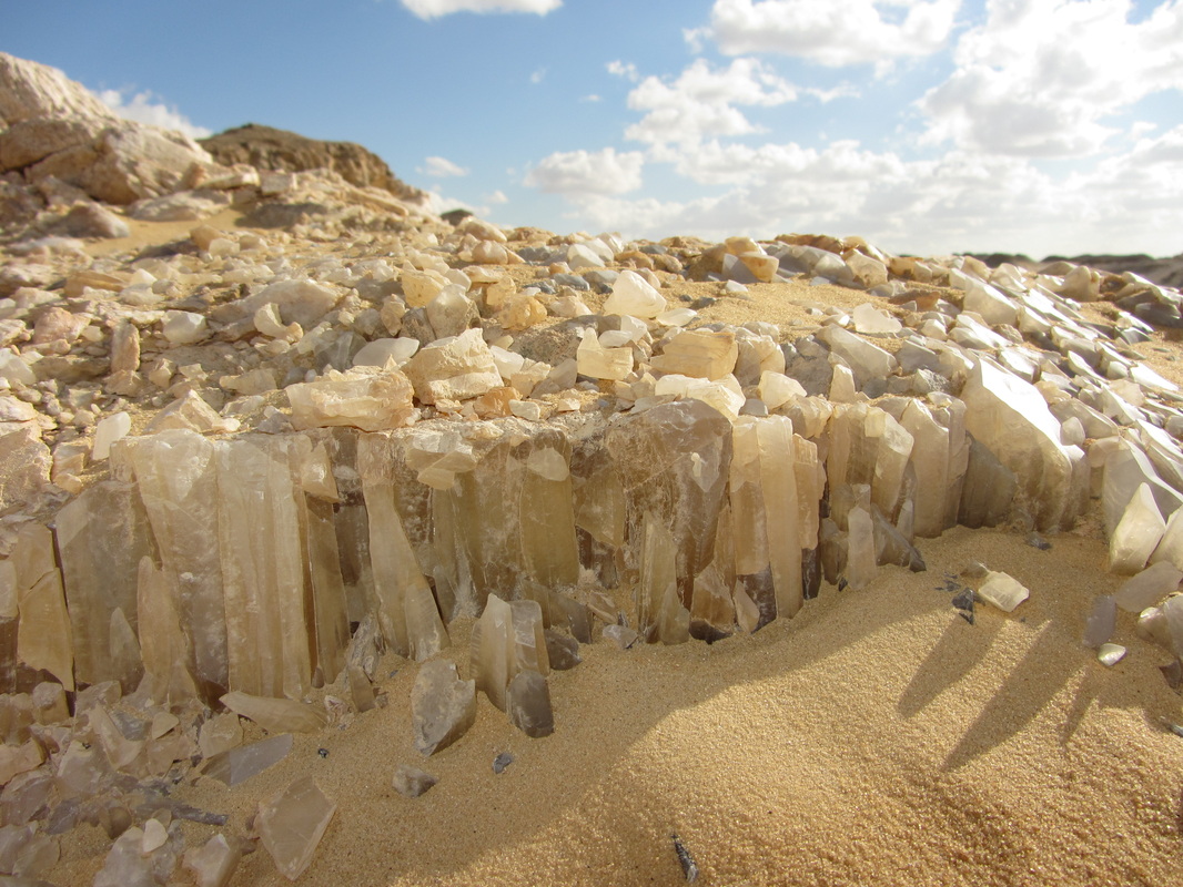
Breccia, conglomerate, steatite, porphyry, granite, dolerite, gold, and amethyst are just a few of the natural resources available in the Eastern Desert.
See Appendix K for a list of raw materials that are found in the Eastern Desert.
Egypt geology Hydrology
In a fascinating paper entitled “Overview of the geomorphological and hydrogeological characteristics of the Eastern Desert” A.A. Adbel Moneim provides the most detailed summary of the hydrology of the Eastern Desert that I have seen to date (Moneim 2005, p.416-425). The data for this section is taken exclusively from that paper.
Monein says that these are very limited as resources when compared to those of the Nile Valley, the Delta, the Western Desert and Sinai: “This is mostly due to the fact that the area is covered in most parts by crystalline rocks (mostly igneous and metamorphic), in addition to the limited sources for the recharge.
Groundwater in the Eastern Desert
may be found in both shallow and deep formations.
Shallow groundwater occurs in the alluvial deposits and shallow carbonate rocks and is discharged either naturally through springs, or through drilled wells of shallow depth.
The deeper water-bearing formations, however, are more extensive and generally provide larger and more reliable well yields” (Monein 2005, p.421).
Today’s rainfall usually consists of rare and heavy downpours over a small area. This runs as storm waters through the wadis, becomes trapped by sediments and debris, and sinks into the surface and into the ground below.
This provides groundwater which enables a certain amount of vegetation to survive, and can be accessed by deep wells of between 8m and 10m in depth.
Rainfall has been discussed in more detail above in the Environment section.
Other water sources are springs – including those at St. Paul’s and St. Anthony’s monasteries which are karstic (fissure limestone) aquifers or groundwater supplies.
Monein (2005, p.419) divides the wadi system into two main groups:
Drainage basins that drain toward the Red Sea Coast (the Red Sea Basin Group)
Catchment area covering about 42,240 km.sq.
Drainage basins that drain toward the Nile (the Nile Basin Group)
Catchment area covering about 105,580 km.sq. (10.56% of the total surface area of Egypt and about ten times the total area of the Nile Valley)
Copied from Monein 2005, p.419
Monein further subdivides wadis into three main classes based on their hydrologic properties (Monein 2005, 421 – and on page 420 lists the wadis that fall into these categories in both the Nile Basin and Red Sea Basin groups):
Class I
Low stream frequency
Low drainage density
High bifurcation ratio
Good chance of downward recharge to the shallow aquifers
Class II
High stream frequency
High drainage density
Low bifurcation ration
Highest flooding probability
Lowest groundwater potential
Class III
Intermediate drainage density
Intermediate drainage frequency
Intermediate bifurcation rations
Moderate groundwater potential
High flooding probability
There are four main water-bearing aquifers in the Eastern Desert (Moneim 2005, p.416 and p.421-424), which provide the main groundwater resources:
The fractured crystalline Pre-Cambrian aquifer
Productive only in the eastern part of the desert adjacent to the Red Sea Coast
Located at very shallow depth in some wadis
Recharged by scarce rainfall through cracks and fractures in rocks
Supplies some hand-dug wells used by modern desert nomads
The water quality is variable and may be fresh to, in the northern part of the Desert, brackish
The Nubian sandstone aquifer (Paleozoic-Mesozoic Clasitc aquifer)
The most productive
Lying on the Basement Complex, composed of sands and sandstone with intercalated clay and shale
Extends through the southern part of Egypt and beyond Egypt’s borders into Libya and Sudan to the west and Saudi Arabia to the east
Varies in thickness between 10 and 120m, and is thickest in the Wadi Qena
Varies in water depth between 4m and 40m
In the southeaster part of the desert there are several permanent srpings along the scarp of the Nubian sandstone – for example in the Wadi Hodien.
Recharge is mainly through rain
The main content of the aquifer is fossil water, stored during pluvial times
The quality of water varies from one place to another, and is quite often brackish
The fractured limestone and sandstone aquifers
Productive only in the eastern part of the desert
Mainly represented by the thick extensive multi-horizon succession of carbonate-rock facies, sandstones, shale and clay located in the northwestern part of the desert
Vary in thickness in different parts of the desert
Mainly recharged from occasional rainfall and stream run-off, and to a lesser degree from underlying aquifers through fractures and fissures
Quality of water varies from fresh to brackish
The Quaternary aquifer
Limited potential
Occurring along the major wadis
Recharged mainly from the occasional rainfall
Shallow groundwater supplies held in Quaternary alluvial deposits dominated by sands and gravels
High storage capacity
Quality of water is generally good
Not extensive and its reliability can vary both by region and by season
Recharge mainly by rainwater and, to a limited extent, upward leakage from the underlying deep aquifer
Some sea water intrusion, which may also penetrate the underlying aquifer
The three layers
A layer of limestone covers most of the surface of modern Egypt.
Beneath this lies a bed of sandstone, and this earlier sandstone is the surface rock in Nubia and southern Upper Egypt, as far north as the area between Edfu and Luxor.
The oldest ground of modern Egypt comprises outcrops of metamorphic and igneous rocks.
River and rock
The Nile River cuts its way north from Sudan; through the sandstone the Valley is narrow, with few fields either side in Lower Nubia and southern Upper Egypt, whereas the limestone Valley in Egypt between Luxor and the Fayum is broader, widening in Middle Egypt with a parallel river branch between Asyut and the Fayum.
Between the Fayum and the Delta, the Valley is narrower again, before the river splits into separate branches, forming a great flat Delta between Cairo and the Mediterranean Sea.
The classification of rocks
Rocks are classified into three main groups, according to the conditions of their formation:
igneous (also called eruptive or magmatic rocks: the solidifed form of magma, the molten material beneath the surface or ‘crust’ of planet earth)
sedimentary rocks (products of decomposition deposited by water, ice or wind)
metamorphic rocks (result of transfromation of sedimentary or igneous rocks under high pressures and high temperatres)
The first two of these general groups can be subdivided further:
Group 1. igneous rocks are divided according to their position at formation:
plutonic (or intrusive) rocks – the magma solidified below the surface of the earth
volcanic (or extrusive) rocks – the magma poured out at a volcanic eruption, and solidified above ground
veinstones – the magma penetrated cracks in adjacent rocks, and solidified there
Group 2. sedimentary rocks are divided according to the material out of which they were formed:
clastic sediments – loose weathered particles such as gravel (broken stone) and sand: in conglomerate rocks, these loose particles are bound by clay, lime or quartz
chemical sediments – from materials dissolved in water
organic sediments – from accumulations of dead animals or plants
The harvest of the desert
At all periods the Egyptians made full use of their soft stones, the limestone and sandstone cliffs along the Valley, for building stone: in general, they used a relatively close source, and so the monuments from Abydos to Cairo are mainly of limestone, and those from Dendera south are mainly of sandstone.
In addition, they quarried the harder rocks in the outcrops north of Cairo (quartzite), at the First Cataract (granite and granodiorite), and north of the Fayum (basalt).
The Saharan deserts to west and east of the Nile Valley in Egypt and Nubia offer a variety of other stones: well-used quarries include the calcite/travertine quarries at Hatnub, south-east of Amarna, and the quarries for sedimentary stones along the Wadi Hammamat, between Koptos and the Red Sea. The Roman Emperors set up more distant quarries, most famously at the source for imperial porphyry.
The desert also provided semi-precious stones such as amethyst, carnelian and jasper.
At several quarries, the ancient mining expeditions left inscriptions immortalising their success.
Stones in Ancient Egypt
some important stones
Igneous Rocks
They can be divided into plutonic and volcanic rocks. Plutonic rocks are solidified slowly underground; crystals are visible with the naked eye. Volcanic rocks are solidified quickly above ground. Crystals are too small to be visible with the naked eye.
Hornblende Diorite
Granodiorite
Granite
Basalt
Andesite Porphyry
Obsidian
Tuff
Sedimentary Rocks
These are rocks comprise of detrital rocks (rocks consisting of fragments of pre-existing rocks) and those formed by chemical precipitation. They are normally classified by grain size.
Siltstone and greywacke
Quartzite
Limestone
Sandstone
Recrystallized and Dolomite Limestone
Travertine/
Calcite
Alabaster
Anhydrite
Green Conglomerate
Red and White Limestone Breccia
no picture available
Metamorphic Rocks
They are formed under high heat and/or pressure from pre-existing rocks (either igneous, sedimentary or metamorphic).
Marble
Serpentine
Steatite
Meta-andesite Porphyry and Amphibolite
Mica Schist
Diorite Gneiss
I. THE WESTERN DESERT OF EGYPT (LIBYAN DESERT):
A. Allam,1986: A regional and paleoenvironmental study on the Upper Cretaceous deposits of the Bahariya Oasis, Libyan Desert, Egypt.- Journal of African Earth Sciences, Pergamon Press, Vol.5,No.4,pp.407-412.
Abstract: The Bahariya Oasis represents an anticline with major prevailing NE-SW major fault system.
The present regional geological study proved that the Earth movement has undergone large changes in the sedimentary facies as well as lateral variation in the thickness of strata.
These sedimentary rocks range in age from Cenomanian to Oligocene: Bahariya Fm. (L. Cenomanian), El-Heiz Fm.(U. Cenomanian), El-Hefhuf Fm.(Turonian-Santonian), Ain Giffara Fm.(Campanian), Khoman Chalk (Maastrichtian), Plateau Limestone (Eocene), and Radwan Fm. (Oligocene).
The chronological sequence of the studied beds as well as the structure of the oasis are dealt with. The distribution of the sediment and its faunal association in the Upper Cretaceous deposits led to the distinction of three major phases of sedimentation which are also discussed in detail.
Results: Within the depression, the main structural feature is the NE-SW fault zone cutting across the centre and separating two completely different lanscapes.
A number of synclines of El-Heiz and El-Hefhuf
Formations are preserved along this fault zone. The fault zone is variously mapped with a throw to the north and a throw to the south; the inclination of the adjacent strata suggests uplift of the southern block, but the author believes that there has been movement in both dorections on the fault zone at different times.
It is possible on a fault pattern model to suggest that the lateral movement was responsible for the compressional synclinal features.
The succession of El-Hefhuf syncline contains chalky limestones of Maastrichtian age, demonstrating that the age of the movement resulting in the compressional features was post-Senonian and pre-Yepresian. Earlier Upper Cretaceous distinct series of faulting have been proposed. However, the present study indicates that the central transverse fault zone has neen active, at least, since the Cenomanian.
The present study attributed variations in lithology with marked changes.
The facies analysis demostrates that in the Bahariya Oasis an apparent draping of sediments took place over the northern block by gradual subsidence of the southern, landward block during the sedimentation. The three models of sedimentation recognized in the exposures of the depression are:
3. Transgressive model (Campanian-Maastrichtian)
2. Regressive model (Turonian-Santonian)
1. Transgressive model (Upper Cenomanian)
Generally , the depositional environment which results from the facies analysis is one of a belt of a shallow marine environment along the central fault zone separating a terrestrially dominated environment in the south from the pure marine dominated environment in the north of the oasis during the Late Cretaceous.
The climate conditions prevailing during the Late Cretaceous in the investgated area were also responsible for such a depositional environment.
These conditions have been proved to be subtropical.
Recent paleogeographic reconstruction has indicated that Egypt was in a near equator position.
————————————————-
Abstract: The present study deals with the biozonation of exposed section at Gebel Mishgigah, which is mainly composed of highly fossiliferous limestones, dolostones and marls. These deposits belong to Mishgigah Member of Wadi Rayan Formation and are of Late Lutetian to Bartonian (Late Middle Eocene) age.
The collected samples were investigated for their microfaunal and nannofloral content. Different associations of calcareous nannoplankton, planktonic foraminifers, ostracods and bryozoans were detected. The depositional environments and paleoecologic factors that prevailed during the sedimentation were also interpreted.
Results: Gebel Mishgigah belongs, geographically to the Fayoum Province; it lies at the eastern scarp of Wadi Rayan Depression.
The oldest exposed rocks , at Wadi Rayan, are of Middle Eocene age. They are divisible into two units: the Wadi Rayan Formation and the overlying Gehannam Formation.
The studied section at Gebel Mishgigah is the stratotype of the Mishgigah Member of Wadi Rayan Formation. It is of Late Lutetian to Bartonian (Late Middle Eocene) age.
This distribution of sediments and the faunal associations in the Mishgigah deposits led to the distinction of two major depositional environments: 1) Alternating shallow, reefal and comparatively deep marine conditions of the neritic zone during the late Lutetian time, 2) Fairly shallow marine conditions during the early Bartonian time to shallow littoral marine environment during the late Bartonian time.
It seems also that within the regressive phase of the Tethys sea, during the late Middle Eocene time, a slight transgression took place at the top of the Upper lutetian. In an inland pelagic sea, white chalky limestones were doposited.
A micropaleontological study of the Mishgigah Member, at its type locality, led to the recognition of two calcareous nannoplankton biozones, three planktonic foraminiferal biozones, two bryozoan biozones and two ostracodal biozones.
Thus, the Upper Lutetian part of the Mishgigah Member at Gebel Mishgigah is characterized by the presence of the older part of the nannofloral Reticulofenestra umbilica Zone (NP 16), the planktonic foraminiferal Morozovella lehneri Zone (P 12), the bryozoan Tremogastrina fourtaui – Steginoporella delicata Zone, and the older part of the ostracodal Loxoconcha vetustopunctatella Zone.
Whereas, the Bartonian part of the rock unit is occupied by the younger part of the nannofloral Retculofenestra umbilica (NP 16) and the overlying Discoaster saipanensis Zone (NP 17), the planktonic foraminiferal Truncorotaloides pseudodobius Zone (P 13) and the overlying Truncorotaloides topilensis Zone (P 14), the bryozoan Tremogastrina fourtaui Zone, and the younger part of the ostracodal Loxoconcha vetustopunctatalla Zone and the overlying Trachyleberis nodosus nodosus Zone.
The boundary between the Upper Lutetian and the Lower Bartonian lies on the top of the Morozovella lehnerti Zone.
The present biostratigraphic zonation can be correlated with the Middle Eocene type locality in Egypt, at Gebel Mokattam, East Cairo.
The Mishgigah Member of Wadi Rayan Formation in the Libyan Desert is the stratigraphic equivalent to the Nummulites gizehensis, Buildingstone and Guishi Members of the Mokattam Formation as well as the Bartonian part of the Maadi Formation described by Allam et al. (1988).
.
xxxxxxxxxxxxxxxxxxxxxxxxxxxxxxxxxxxxxxxxxxxxxxxxx
Egypt geology II. THE NILE VALLEY AND DELTA
A. Allam, M. Bassiouni and A. Zalat, 1988: Calcareous nannoplankton from Middle and Upper Eocene rocks at Gebel Mokattam, East-Cairo, Egypt.- Journal of African Earth Sciences, Pergamon Press, Vol.7, No.1, pp.201-211.
Abstract: This paper discusses the stratigraphic significance and illustrates the calcareous nannoplankton separated from the Middle and Late Eocene sediments at the type area, Gebel Mokattam, East-Cairo, Egypt.
Six nannofloral biozones were recorded: the Middle Eocene Discoaster sublodoensis Zone, Reticulofenstra umbilica Zone, Discoaster saipanensis Zone and Chiasmolithus oamaruensis Zone; the Late Eocene Isthmolithus recurvus Zone and Ericsonia subdisticha Zone.
These zones correspond closely to those established in other regions, and correlated well with the standard Eocene zones.
Presented at: “14th COLLOQUIUM OF AFRICAN GEOLOGY”, Technische Universitaet Berlin-Germany, 18-22 August 1987″
————————————————-
M.A.Bassiouni, A.Allam, M.Boukhary and A.Zalat 1988: On The Occurrence Of Nummulites ptukhiani KACHARAVA At The Base Of Maadi Formation (Bartonian), Gebel Mokattam, East of Cairo, Egypt.- Revue de Paleobiologie,Benthos 86, 3eme Symposium International sur les Foraminiferes Benthiques, Museum de Historie Naturelle, Geneve-Suisse, 22-28 Septembre 1986, Vol.Spec.No.2, pp.615-620.
Abstract: This paper deals with the study of the benthonic foraminifer Nummulites ptukhiani KACHARAVA, in samples collected from Gebel Mokattam, which is regarded as the type locality
of the Middle and Upper Eocene in Egypt.
This species was originally described from Armenia and also is recorded from several tethyan provinces, i.e. Italy, Spain, Libya and Oman. All the auther gave this species an latest Middle Eocene age.
Nummulites ptukhiani KACHARAVA is recorded in this work for the first time in Egypt. It has a taxonomic relationship with N. fabianii group. N. ptukhiani represents the phyletic link between N. bullatus AZZAROLI and N. fabianii (PREVER).
————————————————-
A. Allam, 1982: On the geologic setting of the Nile Delta, Egypt.- Ain Shams Sci. Bull., No. 24, B, 1982 – 1983, p. 35 – 52.
Abstract: The area of the Nile Delta, as a part of northern Egypt, had been subjected to the same geologic events that affected the whole region during its Pre-Miocene geologic history.
The Delta region is bounded on the eastern side by a major upwarp zone which occupies most of North Central Sinai.
This zone extends westwards into “Cairo-Suez Anticlinal Horst”, and is followed , northwards, by a major downwarp zone which occupies most of the Delta region and its extension into northwest Sinai.
The sedimentary section of the Nile Delta, has an anticipated thickness of the more than 12000 m of which about 5000 m belong to the neogene.
The occurrence of such a thick section allows the development of strong gravity faults and structural zones zones particularly in its northern part.
A transition zone from crystalline continental crust to typical oceanic crust occurs along a hinge line extending parallel to the present coast line of Israel and northern Sinai (Ginsburg & Gvirtzman, 1979).
The tectonic features interpreted from the overlying sedimentary sequence of both Paleozoic and Mesozoic times suggest the westward extention of the hinge line to cross the Nile Delta, forming an ESE-WNW fault zone between Mid and North Delta.
This fault zone follows the steep and rapid plunging of the basement complex, similar to the hinge line of northern Sinai and Israel.
No doubt that the development of the Nile Delta through ages till its present form is related to events occurred since the Precambrian.
The Precambrian crystalline rocks underlying the Paleozoic and the Mesozoic sediments are expected at a depth more than 11000 m. The fault zone follows the steep and rapid plunging surface of the basement complex.
These Late Cretaceous step faults dominate in Mid-Delta.
Anhydrite and gypsum deposits were formed during Messinian due to subsidence of Mediterranean Sea.
Finally, a tectonic movement during the Late Miocene caused a lowering of the Sea bottom and thick clinoform sequence of clastic sediments were deposited. Since then, the Nile Delta acquired its present form.
III. THE EASTERN DESERT OF EGYPT (ARABIAN DESERT), GULF OF SUEZ, AND THE EGYPTIAN RED SEA COAST:
Abstract: The late Senonian Duwi (Phosphate) Formation and its lateral equivalents occur as a thin wide-spreed shallow marine deposits with reside in an east-west trending belt spanning the lower middle latitudes of Egypt.
These Egyptian phosphorites lie near the base of a generally transgressive marine squence that was deposited on the outer fringes of the Arabo-Nubian Craton in Cretaceous-Tertiary time. However, the studied phosphorites were laid down within shallow epeiric sea which flanked southern portion of the Tethyan trough.
This study concentrates upon the Duwi (Phosphate) Formation at Wadi Teban, Hamrawein area, along the Red Sea coast of the Arabian Desert of Egypt, where the unit is particularly well exposed.
The porpose of this study is to reconstruct the depositional and diagenetic histories of the entire formation in this area.
Particular attention was given to the phosphatic rocks, which occur in the study succession, as four beds interbedded with limestones, dolostones, mudstones, sandstones, and chert.
Textural and lithofacial studies of Wadi Teban phosphorites show that the cryptocrystalline varieties of apatite (collophane), fluorine rich variety of apatite, most likely francolits, and fish debris are the major phosphate components.
Microfacial analysis showed that these rocks are classified as clastic phosphate rocks because of the dominance of detrital phosphatic and quartz clasts.
A mixture of subangular to subrounded quartz grains and rounded phosphatic pellets and nodules may indicate the complex origin of the phosphorites.
The phosphatic pellets were, for the most part, internally structurless, and they may be interpreted as detrital or may have formed diagenetically.
The quantity of silica , which varies considerably from sample to another, is related primarly to the presence of allogenic minerals (detrital quartz).
The cement is formed of fine-grained phosphatic grains (collophane), carbonates (mainly dolomite) and less commonly silica.
Examination by the scanning electron microscope revealed that apatite appears to favour certain types of surfaces for nucleation. For example, apatite seems to grow actively on the surface of primarily formed phosphatic minerals, replacing biogenic components and within skeletal materials. It seems that part of the phosphatic deposits were formed diagenetically,evidences of replacement of previously existing materials (mainly carbonates) by apatite are observed. Other parts of the phosphorites were formed authigenically; e.g. by direct precipitation from sea water. The euhedral crystal forms and growth of apatite on the surfaces of minerals support formation by precipitation rather than by replacement.
Furthermore, the examination of organic materials and algal coated grains revealed that the oxidation of these organic matters during SO4, reduction is main source of dissolved phosphate.
The studied phosphate succession was deposited during the Late Cretaceous time.
During that time, global sea levels reached a second-order maxima at approximately 71 m.y. ago; this maxima is superimposed upon the great first order (supercycle) sea level rise of the Late Senonian. Following this Late Campanian maxima, relative global sea levels dropped, and continued to fall well into Early Maastrichtian time.
The concentration of the intially precipated apatite into indurated phosphate rocks is probably brought about by physical processes such as winniwing and reworking.
During the period of low sea level, the fine-grained fraction of the sediments is eroded away, concentrating the phosphorite initially into coarse-grained sediments and ultimately into nodular deposits.
————————————————-
A. Allam and K. Shamah, 1986: Microfacial Analysis and Environmental Development of the Duwi (Phosphate) Formation, Quseir-Safaga District, Eastern Desert, Egypt.- Acta Mineralogica-Petrographica, Szeged-Hungaria,Vol. XXVIII, pp. 11-20.
Abstract:Microfacial analysis, based on six stratigraphic sections, were carried out to the Duwi (Phosphate) Formation at the coastal plain of Quseir-Safaga along the Red Sea coast.
The study showed that the main rock types are: phosphorite, organic rich shale, siliceous claystone, glauconitic sandstone, chert, dolomite, and oyster limestone. Detailed field and microfacial investigations of these rock types were done.
The paleogeographical distribution of the Duwi (phosphate) Formation was found to be influenced by biological and chemical parameters which was necessary for precipitation of calcium phosphates. Other factors controlling the areal extent include water depth, wave base and current velocity.
————————————————-
Hilde L.Schwartz and A. Allam, 1985: Preliminary Report on Fishes from the Phosphate Beds of Wadi Teban, Hamrawein Area, Eastern Desert, Egypt.- Egyptian Journal of Geology, Geological Society of Egypt, Vol.29, No.1-2, pp.145-154.
Abstract:A small, preliminary collection of vertebrate remains from the four phosphate beds of the Duwi (Phosphate) Formation includes teeth of both cartilaginous and bony fishes.
The collection was made at Wadi Teban, Hamrawein area, in the Eastern Desert of Egypt. At least three types of shark (Isurus sp., Squalicorax sp. and Ginglymostoma) and one holostean (Hadrodus sp.) occur in the field area. The sharks represent both benthic and pelagic forms and support sedimentological evidence that the Duwi (Phosphate) Formation was deposited in a relatively shallow water marine environment.
See also: Delta Journal of Science, A Periodical of Faculty of Science, Tanta University, Tanta-Egypt, Vol.9, Jan.-Jun.1985, pp.184-195.
————————————————-
Abstract: Gebel El-Zeit area is situated close to the Arabo-Nubian shield, so that it has been affected by Paleozoic (Caledonian and Hercynian) and Mesozoic (Alpine) orogenic movements. This paper deals with the effect of these movements on the facies of the sedimentary rocks.
The study has led to two main conclusions: a) the occurrence of four stages of sedimentation each separated by unconformity; b) the existence of complex inter-relationship between rifting and sedimentation, periodic tilting and fracturing of the horst blocks with erosional beveling of older deposits following each stage of sedimentation.
Results: Gebel El-Zeit area provides an ideal model for the regional tectonics and structural relationships to sedimentary history of the Gulf of Suez area.
The Precambrian granite is unconformably overlain by the Cambrian clastic deposits representing the first marine transgression on the Arabo-Nubian Shield (Araba Fm), followed by alluvial plain, continental environment (Naqus Fm).
After a subtantial hiatus in sedimentation took place, a Cretaceous sequence of alluvial plain, marginal, and shallow marine sandstones, siltstones and silty shales were laid down (Malha, Galala, Wata and Matulla Fms) representing a clear transition from continental to shallow marine depositional environment.
Subsequently, the ranges were extensively faulted, creating a south-westward dip of about 20 degrees in the pre-Tertiary succession.
Erosion then beveled the deposits of the eastern edge of the blocks, exposing the basement rocks.
The following Miocene marine transgression was accompanied by deposition of marine and non marine-coastal sediments (Nukhul, Ras El-Behar, Belayim and south Gharib-Zeit Fms).
It is believed that Gebel El-Zeit area was structurally high during that time and formed somewhat an island at the Gulf of Suez. Following this, a continued uplift tilted the beds to their present position.
During the Pleistocene and Holocene times, the water of the Gulf of Suez advanced over the essentially stationary ranges, leaving subhorizontal limestone terraces and perched beaches. The recent terresterial deposits are primarily coarse clastic alluvial fans, while reefs continued to form off-shore.
Structurally, the oldest clear fracture are the N70E Tethyan trend which is sub-parallel to the pre-tilting land surface.
Active faulting along the E-W Mediterranian trend occurred at the beginning of the Cretaceous transgressive cycle, which is evidenced by growth faulting in the basal Cretaceous deposits.
After the Cretaceous, normal faulting along the Gulf of Suez trend tilted the horst block about 25 degree to the southwest. Shering was resulted due the oppening of the Red Sea which created swarms of Aqaba trend jouints which cut both the basement and sedimentary rocks.
Jointing and faulting along the Suez (Clysmic) trend continued and became dominant with step faulting, parallel to the Gulf of Suez. Arching of the horst created new conjugate cross-faulting, with reactivation of older trends. In general, initial fracture trends in the sedimentary cover were inherited from, or simultaneous with trends in the basement rocks.
————————————————-
Abstract: The present work deals with the sedimentological and palaeoenvironmental studies of the Palaeozoic clastic sequence (Cambrian) of the Gebel El-Zeit area.
The sandstones which build up the major part of this sequence are fine to coarse grained moderately to well sorted, mostly of unimodal patterns, strongly fine skewed to near symmetrical and vary from meso- to very lepto-kurtic.
The grain-size parameters and their bivariate relations do not give an exact environment of deposition, nevertheless, most of them have a fluviatile origin.
So, the application of some of the bivariate relations to ancient sediments, which microscopically show mild or no cementation, is still valid if coupled with other parameters, such as sedimentary structures, palaeocurrent analysis and other confirmed data.
The palaeocurrent analysis indicates that these sandstones came from two completely different sources.
A marine transgression from the north northeast produced the Araba Formation (Lower Cambrian), whereas the Naqus Formation (Upper Cambrian) has been interpreted as fluvial. The source is situated to the south southwest. The streams were probably very erratic and intermittent.
Egypt geology IV. SINAI
Abstract: The Paleozoic sandstone succession between Wadi Feiran and El-Tor in southwestern Sinai has been subdivided into five distinct lithostratigraphic units: the Lower Cambrian Araba Formation, the Upper Cambrian Naqus Formation, the Lower Carboniferous Abu Durba Formation, the Upper Carboniferous Aheimer Formation and the Permian Qiseib Formation.
The present study has also proved that the Paleozoic Earth movements have undergone distinct changes in the sedimentary facies, together with lateral variations in the composition and thickness of strata.
The distribution of the sediments and their faunal contents point to the existence of five major phases of sedimentation during the Paleozoic Era.
Results: The Lower Cambrian, in the Gulf of Suez region, is marked by the invasion of the Tethys Sea from the north. The Araba Formation includes the first clastic beds of this major marine transgression.
It is distributed in the Gulf of Suez region as an E-W parallel body reflecting an undulated surface of the underlying basement.It is thin and uniform in thickness.
The presence of bioturbations at the base of the formation, as well as the cross stratification of the following beds and the fossil contents may suggest that the Lower Cambrian sandstones were deposited on a shallow marine platform with low relief, and hinterland to the south and southeast of the studied area.
The following Naqus Formation becomes increasingly fluviatile to continental.
The unfossiliferous sands and pebbles of this formation were deposited at a regressive phase of the sea. The formation is uniformly thin north of latitude 28 30 N, and increase in thickness towards the south in the subsurface.
Further south, the Naqus Formation also thins gradually. It seams that the studied area has been affected by a down to the south fault in the Early/Late Cambrian times, towards the downthrown side, the Naqus Formation was deposited.
Therefore, the areas of thick Naqus deposits (southward) are overlain by clastic sediments of Abu Durba Formation, whreas the thin Naqus deposits (northward) are overlain by the carbonates of Um Bogma Formation.
During the Early Caboniferous there was a second north to the south marine transgression (Late Paleozoic transgression) in the Gulf of Suez region. Abu Durba Formation represents this widespread transgression by buff-grey to blue claystones with dateable fossils together with fine medium-grained sandstones.
To the north of the studied area, the clastic sediments of the Abu Durba Formation are laterally changed into marine carbonates of the Um Bogma Formation.
Therefore, it is believed that the depositional environment of Abu Durba Formation and its equivalents range from inner sublittoral, partly restricted, to outer sublittoral conditions.
The degree of variability of depositional environments implies a submarine relief of some magnitudes.
Furthermore, the thin carbonates of the Um Bogma Formation seem to be deposited on the upthrown side of the forementioned fault system, whereas, the thick clastic sediments of the Abu Durba Formation were deposited on its down thrown side.
A down to the north fault (or fault system) has affected the studied area at the end of the Carboniferous time.
The thick carbonate sediments of Ataqa Formation were deposited in the downthrown side.
The upthrown side recieved the marne shales of Aheimer Formation.
The Ataqa Formation is restricted north of latitude 29 N and its equivalent to the south is the clastic Aheimer Formation.
These two units probably represent the last major transgression of the Tethys Sea during the Paleozoic times.
The present Aheimer Formation starts with green shale at the base and ends with sandstone lenses at the top.
A lagoonal system could be responsible for the deposition of the marine shales, whereas, the sandstone lenses may represent fluviatile channel deposits.
The distribution of sediments may suggest a deposition in a transgressive-regressive sea which is adjacent to the shoreline.
Therefore, the Aheimer Formation is most prbably marine at the base and non-marine at the top.
At the close of the Carboniferous and the advent of the Permian the Tethys Sea regressed totally from the studied area. The continental red beds of the Qiseib Formation were deposited in a wide braid plain.
Presented at: “30th INTERNATIONAL GEOLOGICAL CONGRESS(IGC), 4-14 August 1996, Beijing-China”
————————————————-
Abstract: The present study is based on 1:40000 scale mapping of the area between Wadi Feiran and El-Tor area, Sinai.
The Photo-geological map is more detailed than the previous ones.
The study include details on the litho- and biostratigraphy, especially of the Late Cretaceous – Tertiary sequence, and on the facies changes within the outcropping rock-units.
Results: It is well known that the granitic Precambrian shield forms the highland of Sinai. The Cambrian and younger subaerial erosion of this Precambrian shield has led to the deposition of thick and widespread Nubia Sandstone.
The absence of any basal conglomerates in the lower sands suggest that the lower Nubia Sandstone was deposited in a shallow marine platform with low relief.
A hinterland to the south and a basin to the north is als inferred. The widespread and uniform nature of the lower Nubia Sandstone implies a Paleozoic epicontinental to shallow marine shelf of large dimensions.
It is suggested that this shelf may have extended far northward in Sinai throughout the Paleozoic Era.
During the Permo-Carboniferous time there is a north to south widespread marine transgression in the mapped area. The geologic record of this transgression is represented by clastic sediments with dateable fossils.
The depositional environment in that time implies a submarine relief of some magnitude. It ranges from inner sublittoral, outer sublittoral to bathyal marine conditions. Earth movements during the Permo-Carboniferous time are suspected. At the end of the Paleozoic Era the sea withdrew from the mapped area.
The characteristics of the Early Mesozoic Nubia Sandstones which are interbedded with fossil soils with root structures and fossil trees, indicate a fluviatile to deltaic depositional environment. The sandstones were probably eroded from the surrounding igneous and metamorphic rocks, so that it would be possible that the depositional environment ranged from braided fluviatile systems to marginal or shallow marine settings in ahigh energy low braided streams.
The Cenomanian begins with the first appearance of marine beds above the Nubia Sandstone.
The transition from clastic to an entirely marine section occurs over few metres. The facies characters of the Cenomanian rocks indicate a fairly shallow transgressing sea.
The upper part of the succession shows alternating shallow and comparatively deep marine facies. This phenomenon would suggests an oscillating shallow sea, especially during the Late Cenomanian when this sea became gradually deeper at the beginning of the Turonian.
The Late Cretaceous sea continued its transgression during the Turonian, where compratively deeper marine conditions prevailed.
This was evidenced by predominance of limestones and dolostones and low clastic ratio. The presence of dolomite indicates a stable sea-margin-environment. However, this Turonian sea was receiving, at interval, subordinate amounts of terrigenous material from a neoghbouring southern landmass.
The abundance of detrital grains and the pelletal nature of the Lower Senonian rocks indicate a predominant shallow marine condition of the neritic zone. This shallowing of the Late Cretaceous sea would suggest a crustal uplift of the sea floor about the end of Turonian time.
The clastic sediments of Lower Senonian age is followed by a chalky sequence of Upper Senonian age, which indicate deposition under deeper marine conditions far from any terrigenous material. It means, the shallowing of the Lower Senonian sea was followed by a reversal in the secular oscillation of the sea floor. However, the orogenic movements which affected the northern parts of Egypt along the NW-SE Syrian arcs, were not active at the mapped area because the Paleocene deposits conformably follow the topmost Upper Senonian beds. The Paleocene sediments show open marine outer neritic facies environment.
It seems that the marine conditions during the Paleocene time were, more or less, similar to that obtained during the Late Senonian.
The beginning of Early Eocene was the time when the transgression of the sea was either halted or had a slight regression. The crustal stability has produced a deposition of uniform open-sea facies of the limestone with flint.
By upper Lower Eocene time a regression of the sea started, and the reefal alveolinid limestone facies was formed under shallow marine conditions.
The Late Eocene transgression of the sea must have continued probably to the end of Oligocene time.
Therefore, the Middle Eocene sea was gradually regressing, due to the appearance of larger foraminifers above the Lower Eocene beds.
The Oligocene in Sinai was marked by general uplift accompanied by igneous activity. The igneous activity was represented by the Early Tertiary basalt flows which was generally interpreted as related to initial faulting in the Suez rift.
The onset of rifting is defined in the present map by unconformity.
The erosion which occurred appears to be restricted to the Upper Eocene limestone. A shallow proto-rift depocentre was first formed in which the lower part of the Gharandal Group was deposited. As the sea-level rose through the Aquitanian and Early Burdigalian, successive formations onlapped the margins of the developing depocentre. The subsequent deposition of the upper part of the Gharandal Group, comprise lagoonal and subsequent marginal and shallow marine sequence, and reflects major sea-level changes. The Lower Miocene deposits were succeeded during Middle Eocene (Serravallian) time by prolonged sedimentation of reef building carbonates in the mapped area. These reefs, which constitute the Belayim Formation marks the last occurence of marine fauna in the Miocene.
The reefal coditions wre gradually changed to progressive aridity, leading to the prolonged formation of evaporites of Ras Malaab Group during Turtonian and Messinian times. The evaporitic deposits were accumulated under very shallow epicontinental sea.
Finally, at the close of Miocene time, aridity ceased and gave way, during Pliocene-Pleistocene times, to the sedimentation of clastic materials in southwestern Sinai. The Pliocene-Pleistocene deposits, in the mapped area, have mainly terrestrial facies. They are mostly composed of gravels and conglomerates with some anhydrite interbeds.
This seems to indicate that occasional marine transgressions covered the area.
Abstract: Two planktonic foraminiferal biozones were recorded from the Early Eocene beds of Gebel Qabeliat, Gulf of Suez, Sinai: Morozovella subbotinae Zone and Morozovella formosa formosa Zone.
The corresponding calcareous nannofossil biozones are: Tribrachiatus contortus Zone, Discoaster binodosus Zone and Tribrachiatus orthostylus Zone.
The near absence of microfossils in the upper Lower Eocene section probably points to a change in the paleoecological conditions in the studied area during that time.
Resumption of reefal environment is confirmed by the up-sequence appearance of the larger foraminifers.
Early Eocene planktonic foraminifers and calcareous nannofossils zones recognized in the study section for the first time are broadly similar to those recorded in Israel and many parts of the world.
————————————————-
Abstract: Several black shale beds are located within the middle part of the Carboniferous sandstone succession of Ataqa Formation at Beaa-Um Thora district in west Central Sinai.
The organic geochemical characteristics of these shales have been studied to evaluate their hydrocarbon potential.
The obtained results show that black shale beds have a uniform mineralogical composition allover the studied area.
The average of carbonate and silicate contents of these shales are 16.04 and 66.39 percent respectively.
They contain also high bitumen, organic matter and TOC contents, which are enough to consider them as a potential source rock for generating hydrocarbons.
Pyrolysis results indicate that, the organic matter in these shales belongs mainly to mature Type II kerogen with marked amount of types I and III.
In addition, these kerogens show a wide range of maturity levels; from low to high mature.
The significant variation of maturations attributed to the different geothermal effects in the area.
Coal bodies are classified as a humic coal of hard brown coal to bituminous hard coal rank stages of low economic value.
————————————————-
A. Allam and H. Khalil, 1988: Geology and Stratigraphy of the Arif El-Naga Area, Sinai, Egypt.- Egyptian Journal of Geology, Geological Society of Egypt, Vol.32/1-2, pp.199-218.
Abstract: The sedimentary succession at Gebel Arif El-Naga in northeastern Sinai is subdivided into eleven distinct lithostratigraphic units, which range in age from Triassic to Eocene:the Anisian Arif El-Naqa Fm., the Ladinian to Lower Carnian Abu Nusra Fm., the Hettangian Rajabiah Fm., the Pliensbachian Shusha Fm., the Aptian to Albian Malha Fm., the Cenomanian Halal Fm., the Turonian Wata Fm., the Coniacian Mezera Fm., the Santonian to Maastrichtian Sudr Chalk, the Paleocene Beida Fm., and the Middle Eocene Foyah Foyah Fm.
The Arif El-Naga area is situated close to the Arabo-Nubian Shield, the Suez Graben and the Aqaba-Dead Sea Rift.
It has been affected by different tectonic movements from the Senonian onwards. The study deals also with the complex interrelationship between tectonics and sedimentation.
It proved that tectonic movements have caused distinct changes in sedimentary facies, exhibited as lateral variations in the composition and thickness of strata.
Delineation of the spatial distribution of the rock units was aided by photogeological mapping of the area.
In brief, the Arif El-Naga area is covered by a sedimentary succession predominatly deposited in shallow platform environment.
The Triassic rocks (Arif El-Naqa and Abu Nusra Fms.) are exposed in the core of the anticline. They unconformably underlie the Lower Jurassic beds. It seems that the studied area was folded above the sea at the end of the Triassic. The area formed a regional high from which the upper Triassic deposites were eroded.
The Lower Jurassic exposures at Gebel Arif El-Naga demonstrate an inner shelf clasic series (Rajabiah and Shusha Fms.). The fact that no Middle or Upper Jurassic units are found in the studied area could be taken as an indication that this area was structurally high near the end of the Jurassic.
A regional uplifting was probably responsible for the nondeposition or erosional truncation of the Middle and Upper Jurassic sediments.
A regional stratigraphic gap underlies the fluvio-continental deposites of the Lower Cretaceous (Malha Fm.).
Following this general regression of the sea, a transgressive carbonate depositional phase was then started (Halal Fm.).
It progressively onlapped the Malha Formation in the southward direction. The observed small changes in thickness and facies are probably a result of a tectonic movement during the Cenomanian to Early Turonian.
During the Late Cretaceous, the northern Sinai shelf platform was covered by chalky and marly deposits (Sudr Chalk).
Thickness changes are due to local morphotectonic features. It is blieved that the folding during the Campanian further tilted the inclined Cenomanian beds to near verticality and uplifted the southern flank of the Arif El-Naga structure thus exposing it to erosion.
The folding was accompanied by intense erosion of the elevated core area down to the Jurassic resulting in a breached anticline.
The Paleocene is represented in the studied area by the Beida Formation. Unconformities and stratigraphic gaps are obseved below and above this formation, probably due to synsedimentary tectonics, in particular to the folding of the Syrian Arc.
This folding movement seems to have become strong enough to bring the area above sea level. However, during the Eocene time, the synclinal areas around Arif El-Naga anticline were submerged by schallow water.
The deposited Middle Eocene sediments (Foyah Fm.) are thin compared to those known from the Egma (Egypt)and Avedat (Israel) Plateaus.
Furthermore, the Foyah Formation unconformably overlaps older sedimentary units of different ages. It is therefore, believed that the folding movement continued during the Eocene and later times.
Sinai, the triangular-shaped peninsula of Egypt, is situated between Asia and Africa. The separation of the two continents caused the form and geographical shape of Sinai the way it looks today.
Sinai is approx. 380 km long (north – south) and 210 km wide (west – east). The surface area has an extension of 61.000 km², the coasts are streching about 600 km on the west and on the east. On the western part there is the Gulf of Suez (with the Suez channel) and the eastern part of Sinai brings up the much deeper Gulf of Aqaba.
The sea in the Gulf of Suez measures approx. 80 meters only, while the profile of the Gulf of Aqaba goes down to approx. 1.830 meters. The latter is a part of the big land rift that extends until Kenya.
Big siesmic activity and the tremendous eruptive phenomena have given Sinai its characteristic looks. The highest mountains are the Gebel Musa (Moses’ mountain) with 2,285 metres, and the Sinai’s highest mountain Mount St. Catherine (Gebel Kathrina) with 2,642 metres.
Many of the Pharaohs got their precious stones from the southern Sinai.
The west coast – reaching from Ras Mohammed to Taba – is filled with rich coral reefs sections, one after another.
This under water paradise is giving ideal conditions for flora and marine fauna, and finally nowadays for divers.
The northern part of Sinai mainly consists of sandstone plains and hills. The Tih Plateau forms the boundary between the northern area and the southern mountainous with towering peaks.
WDNP is part of a hyper arid, hot desert area, which rarely receive any rainfall. The climate is extremely harsh.
The summer maximum daily temperature can exceed 41.5 C while in winter daily sunshine warm weather and very low at night less than zero.
The average monthly evaporation ranges from 7-2 mm/ day during December to 24.1 mm/ day January.
The relative humidity generally low, ranging from 5 % in winter and up to 56 % in the summer. The wind direction generally is blowing from the north-west.
Egypt geology
The White Desert (Sahara) is a unique geological phenomenon
The White desert is a unique geological phenomenon; where wind and water erosions sculptured their way through the soft chalk forming incredible shapes and silhouettes.
In its area, sprout several springs that supplied much of the needed water to the caravans. Walking through the White Desert is a monumental experience.
It is located in the Libyan Desert, approximately mid-way between Dakhla and Bahariya.
Farafra has an estimated 5,000 inhabitants (2002) living within its single village and is mostly inhabited by the local Bedouins.
Parts of the village has complete quarters of traditional architecture, simple, smooth, unadorned, all in mud colour.
Local pride has also secured endeavours to secure local culture.Also located near Farafra are the hot springs at Bir Setta and the El-Mufid lake.
A main geographic attraction of Farafra is its White Desert (known as Sahara el Beyda, with the word sahara meaning a desert).
The White Desert of Egypt is located 45 km (30 miles) north of Farafra. The desert has a white, cream color and has massive chalk rock formations that have been created as a result of occasional sandstorms in the area.
The Farafra desert is a typical place visited by some schools in Egypt, as a location for camping trips.
Geomorphology and Topography
According to the geomorphologic system of Egypt, the Farafra oasis lies within an oval shaped depression, which is bounded by scarps from the eastern, northern and western sides where, as it is open due to the south the longer axis of the depression is 102 km, where as, its east west axis measured near the middle of the depression is about 90 km.
The depression is covers an area about 980 km2.
The floor of the depression is covered by the Dakhla Formation in southern part.
Northward covered by chalk of Maestrichtian age (Khoman chalk), and sand sheet with some sief dunes on top covers the eastern part of the depression.
The WDNP is located in northern part of Farafra Depression the area has been under arid climatic conditions since the very late Pleistocene.
Hence, erosional processes are mainly due to wind action temperature variation and occasional low rainfall. The general relief of the area is relatively low.
The maximum height is about 353 m above sea level at El Quss Abu said south western part of the park, and the minimum reaches about 32 m above sea level at Wadi Hennis, Ain El Wadi and Wadi El Maqfi areas these areas are coverd by wet sabkha
The beautiful landscapes of white Desert today ( mushrooms, towers, and shapes sometimes resemble mysterious animals, camels and sphinxes ) is a result of a very long depositional history under the various geological sedimentolgical regimes and palaeoenvironmental conditions, followed by the minor tectonic movements and finally by surface processes that etched the present beautiful landscape.
The rocks exposed in the White Desert National Park are of sedimentary nature and range in age from Cretaceous to recent.
In general, stratigraphicall
y rock units of White Desert can be easily divided into five sedimentary rock Formations in ascending order are the El Hefhuf, khoman, Abdullah / Tarawan, Esna shale and Farafra limestone Formations. These are brief notes on each of them:
El Hefhuf Formation:
Age: (campanian)
Type section: Gebal Hefhuf, Bahariya oasis
Stratigraphic position: Underlie the khoman chalk and overlies the Bahariya formation of cenomanian age.
Lithology: El Hefhuf Formation is the oldest rock formation in White Desert, named by Said (1962). It is made up of white to grayish yellow sandstones shale sandy clay and following by phosphatic band and dolostone on the top.
In the Wadi Hennis the El Hefhuf Formation is 35 m thick and made up of varicolored shale, clay, siltstone and sandstone intercalations, capped by a yellowish brown, hard, vuggy, crystalline phosphatic sandy dolostone bed 4 m thick contain badly preserved Ostrea sp and undefined shell fragments.
El Hefhuf Formation contains fossilized woods especially at Wadi Hennis and wadi El –Obeiyid.
The khoman Formation:
Age: early Maastrichtian
Type section: Ain khoman western Bahariya oasis
Stratigraphic position: It is conformably overlies the El Hefhuf Formation and underlies Abdullah limestone
Lithology: this formation made up of white chalk, were deposited here during the Late Cretaceous, about 70 million years ago, when the sea coverd the vast area of western desert and deposited of chalks reflect deep marine conditions, the chalk is characterized by a great number of joint filled with calcite veins, small iron – rich pipes and pyrite concretions.
The floor of white desert are partly covered by small fragments of pseudomorphs of iron oxides after pyrite.
Abdullah limestone / Tarawan Formation
Age: (Late Paleocene)
Author: Le Roy 1953
Type section: Ain El Maqfi – White Desert National Park-(Frafra Oasis)
Stratigraphic position: overlies the Khoman Formation and underlies the Esna Formation
Lithology: thin bedded calcareous, chalky shale to argillaceous limestone chalky limestone with marl bands in some parts followed by gravels boulders and cobbles from limestone and chert.
Esna shale: late Paleocene – Early Eocene
Author: Beadnell 1905, Said 1960
Type section: Gebal Aweina ( Esna)
Stratigraphic position: overlies the Tarawan chalk and the Abdullah limestones and underlies the Frafra limestones.
Lithology : laminated green and grey shale and marl with carbonates intercalations, becoming more calcareous near top.
Farafra limestone (lower Eocene) include Nummulites sp
Author: Said 1960
Type section: El Quess Abu Said (south western part) of White Desert National Park
Stratigraphic position: overlies the Esna Shale Formation
Lithology: white to earthy grey, hard limestone
The limestone or chalks were deposited at the end of cretaceous period, when this entire region was under marine water
The “Crystal Mountain” in Egypt
A subvolcanic vault, filled with crystals of a hydrothermal event
last update: 28.05.2010
It should once be put right, that the crystals from the known Crystal Mountain (28° 26′ E and 27° 39′ N) between the oasis Bahariya and Farafra, northern of the White Desert, are no Quartz crystals. They are probably Barite (Schwerspat, BaSO4) and/or Calcite crystals (Kalkspat, CaCO3), which to ascertain at the hardness of the crystals easily. Quartz (SiO2) has the hardness 7, Barite and Calcite the hardness 3.5-3.0 (after Mohs-scale). Quartz crystal can scratch glass, Barite or Calcite can it not.
The origin of this Crystal Mountain is interesting. The hill was opened during works at the road from Farafra to Bahariya by chance and destroyed in part. The material was installed into the road. Today is the Crystal Mountain a popular stop for the tourists.
Still more interesting is the geological context. The hill is not a paleokarst cave with columnar-shaped stalagmites. It is a subvolcanic vault, which was emerged probably during the Oligocene age. The visible layers are e.g. White Desert limestone of the Khoman Fm.* (Late Cretaceous age), as well as a younger coal seam and hydrothermal impregnated reddish to brownish ferruginous layers. The strata are broken or brecciated and intensely with each other folded. It is to be ascertained intense heat.
The coal seam e.g. was transformed to anthracite (?).
The crystals have increased out of climbed hydrovolcanic solutions.
The hot solutions were high concentrated with BaSO4 and/or CaCO3, which had been solved from the sediments. The solutions have penetrated into all cavities.
After cooling of the solutions the crystals could increase.
It were formed columns or round domes with crystals within.
* The white limestone of the Khoman Formation is dated as middle to latest middle Maastrichtian (Gansserina gansseri and Contusotruncana contusa foraminiferal Zones).
An open marine, warm Tethyan outer shelf environment of deposition is inferred.
“High grade Barite mineralization is found mainly in the form of different veins restricted to the ground surface of Bahariya depression.
The barite veins trend in different directions and are actually associated with the major folds and faults that are restricted to the oldest rocks of Sabaya Formation which form the floor of the depression. The latter occurs within a major northeast trending belt of considerable extension about 100 km long and 40 km wide. Several other folds of the same or later tectonic phase but of lesser extension occur parallel to or perpendicular to the main anticlinal trend.
The Barite veins are widely distributed to the south of Gebel El Hafhuf which is composed of a rock sequence including sandstone, shale, limestone, phosphatic limestone and phosphatic calcareous sandstone. This succession is capped by the Oligo-Miocene basaltic sheet which takes the form of open circle of about 20 m thickness.
The barite veins are restricted to the fractures that are parallel to the main E-W or NW-SE striking faults in the Sabaya Formation.
These veins occur subparallel sets with more than 7 m length and ranging in width between 0.5 to 4 m.
These veins are numerous and distributed in association with tectonically formed fractures and fissures.
Barium was leached from the basaltic extrusion during high temperature circulation. Tertiary Oligocene basalt at Gebel El Hafhuf, Bahariya Oasis is related to continental intraplate volcanism. Fumarolic and geyser activities belong to Oligocene period were consider as gas maar resulting from a phreatic explosion.
Release of sulphate fluids from the sulphate-rich minerals involved in the Brine deposits distributed within Bahariya Depression at the Quaternary, namely polyhalite, kieserite and kyanite.
Migration of these fluids through the deformed strata followed by barite mineralization as a result of a rapid primary precipitation at or above the sediment / fluid interfaces.
The crystals are transparent to translucent and are generally present in the form of angular to subangular shape.”
Further hydrothermal structures in the environment of the Crystal Mountain
Crystals also on hydrothermal fissures in the White Desert !
Egypt geology
Driving through the desert in search of whales sounds counterproductive, but I had been assured that if I hired a jeep and drove seventy kilometres from Egypt geology Faiyum Oasis out into the Sahara this is indeed what I would find. If this was a ruse it was a clever one, and UNESCO were in on it.
The cream coloured 4×4 arrived at nine AM. Perfectly on time – a good sign.
The driver, Mohammed, was a youngish man, perhaps in his early thirties, sporting a thick goatee beard and wearing a red and white chequered headscarf.
He smiled and shook my hand. He had a confident air about him; this was reassuring as effectively, out in the desert, my life would be in his hands.
The vehicle was less reassuring. Of unknown origin, it looked as if it had been driven from Russia the long way around the planet.
On one side it was painted with the words, ‘Land Croser’, and on the other, ‘Land Roser’; a leaping leopard was emblazoned upon the front doors on both sides, but the image to the right had faded until only the leopard’s spots remained to form its feline shape. The vehicle was clearly the closest a machine could get to being un-dead, having been resurrected again and again by Egyptian shamans of engineering.
A young boy of thirteen or fourteen sat in the front passenger seat; apparently he was coming along for the ride as Mohammed’s apprentice.
This was again reassuring; it meant that Mohammed had done this sort of thing before, at least enough times to act as a teacher. The sombre shape of the vehicle was now less threatening and became more a symbol of adventure, something a more perfect machine couldn’t embody. My mind began to draw pictures of the rickety old jeep, driven by Mohammed, valiantly fighting through the desert dunes to the isolated valley where I would find the remains of ancient whales jutting out picturesquely among the rocks.
Despite the reassurances, my initial nervousness of travelling in this part of Egypt was well founded in experience.
The first time I’d visited the Faiyum my trip had been violently brought to an abrupt standstill by an exploding tyre.
I spent the second journey huddled up at the back of my taxi, trying to keep myself warm after the windscreen had been shattered by some unseen high velocity projectile. In order to keep moving the driver had punched a hole in the shattered glass just big enough to see out.
Naturally, this odd situation received no attention from the police. I had decided then and there that my travels in the Faiyum were cursed. Heading out into the middle of the desert in an old soviet ‘Land Croser’ could thus, very reasonably, spell doom. Just as my mind had drawn romantic visions of desert travel and ancient remains, my mind also drew images of a burnt out soviet wreck far from the road, half buried in a dune, the pathetic charred remains of a leopard barely visible on the blackened, baked side of the vehicle, Mohammed wandering in circles dazed and confused in the darkness, while I stand alone wondering how long it would be polite to wait before I could kill and eat Mohammed and his apprentice, cooked over the burning remains of our 4×4, in a desperate bid for survival.
The contrast seen by the ancient Egyptians between the fertile Black Land of the Nile Valley and the chaotic desolation of the Red Land – the desert – is still very noticeable to anyone travelling from the lush agricultural Eden of the fields into the Western Desert. Driving through the Faiyum I was met by scenes of leaning palm trees, all bowing in the same direction to some unseen master, donkeys carrying heavy loads twice their size, farmers standing in the fields carefully tending their crops in the sun, and bored looking cows and gamoosa-water buffalo standing and staring contemplatively at passersby. Behind them all, Lake Qarun was glimmering in the sunlight, while the distant desert hills beyond glowed a yellowish-red, emanating and sweating heat.
The whales were in Wadi El Hitan, ‘The Valley of the Whales’, deep within the Wadi Al Rayan Protected Area just south-west of the Faiyum Oasis.
In the 1970s three artificial lakes were created here consisting of agricultural drainage water from the Faiyum, although one of these lakes had since dried up.
In recent times the area has become a popular weekend holiday destination for Cairenes wanting to escape the bustle and pollution of the city.
In 1989 the Wadi Al Rayan was designated a protected area, not surprising given that it is rich in wildlife and geological attractions, including a small oasis, waterfalls, and a large and varied bird population. My aim, however, was just to see the whales.
Although Wadi El Hitan had become Egypt’s first natural World Heritage Site in 2005 it is still only accessible by a desert track that leads off from the main asphalt road which connects Wadi Al Rayan’s major attractions; it is also much further out into the desert than any other tourist site within the protected zone.
It thus emanated a sense of isolation, adventure, and danger, beyond the typical tourist experience, and so appealed to the moustachioed hat-wearing Nineteenth Century adventurer within me. Finally I could escape the tourist circuit, the herds that cram the Pyramids of Giza and the temples of Luxor. This would be man-versus-desert in the untamed wilderness that exists beyond visitor’s centres, informative panels, and loud-mouthed guides.
Bumping along the road that leads out of the fields of the Faiyum and into the Sahara I watched as the desert changed before me. Just in the space between the entrance to the Wadi Al Rayan and the turn off to Wadi El Hitan, twenty-five kilometres away, it had morphed from dark and speckled to white and clean, to golden dunes, and then back again to clean and flat. Here tyre tracks led off-road in all directions, criss-crossing one another as they disappeared into the distance; apparently no-one felt compelled to adhere to the occasional ‘no off-roading’ and ‘stay on track’ signs that would whizz by. Mohammed ignored them too, alternately riding on the asphalt road and hopping off to bump along the desert surface. He preferred driving on the desert itself he explained, as I lost a few more brain-cells from high-speed impacts with the ceiling, thrown around like a caged bird shaken by a naughty child.
A small sandstorm began, arising unexpectedly; Mohammed brought the ‘Land Croser’ to a halt. All around small particles moved together in a violent dance ruled by chaos theory and thermodynamics, ramming the vehicle from all sides.
My previous cursed trips to the Faiyum flashed before my eyes, and I began to consider who to eat first. Unperturbed, Mohammed and his young apprentice calmly opened their doors, stepped outside and performed some unseen checks on the engine.
They returned soon after and the ‘Land Croser’ roared to life. (Non)-disaster averted, we turned down the desert track to Wadi El Hitan, leaving the asphalt road behind.
After crossing a large expanse of clean white desert, rippled like ocean waves frozen in time, a simple entranceway slowly emerged from the dusty horizon. Red and divided in two by the desert track, it marked the entrance to the site. We continued along the road for a short time, passing large rocky hills on the right, while, unexpectedly, a large visitor’s centre grew closer and closer in front of me. A visitor’s centre? The moustachioed hat-wearing Nineteenth Century adventurer within choked and spluttered on his Earl Grey. A visitor’s centre! This didn’t fit my courageous, lost-in-the-desert-perhaps-having-to-eat-my-own-driver fantasies. Instantly, upon arrival, I exited the ‘Land Croser’ and surveyed my surroundings; the first striking feature was that there was a multitude of buildings, all constructed to aesthetically fit the landscape – domed mud-huts with irregularly shaped windows, made entirely from local natural materials.
They were reminiscent of ancient desert dwellings or Luke Skywalker’s house on Tatooine. There was a gift shop and snacks available in the picnicking and sheesha area, camel hire, toilets and a police hut. Information panels described the site, and maps were free, all bearing the acronym UNESCO. Damn you UNESCO, I seethed, such comfort and safety shouldn’t exist in the dangerous expanse of the desert, they should have more respect for my preconceived ideas. I was in the middle of nowhere, the toilet should be a hole behind a rocky outcrop, my drinks should be the ones I foolishly forgot to buy before leaving the Faiyum, I should be in danger of being eaten by a desert fox at least once. I had travelled from a natural oasis to a man-made one.
Nevertheless, I took a map, used the modern clean bathroom, and bought a coke from the snack shop in which, unexpectedly, Mohammed’s pregnant wife worked. So much for the dangers of the desert, my hazardous expedition into the unknown – this was a daily commute for a pregnant woman. Mohammed and his apprentice went off to sit and drink tea and chat with the other men idly passing their day smoking sheesha in the covered picnic zone. It was time to find those whales.
The path to the whales was clearly marked out by rows of red rocks. I followed them to the first exhibit which displayed the fossilised lower jaw bone, ribs and vertebrae of an ancient whale known as Basilosaurus Isis, a type of whale that still had functional hind limbs from an earlier phase as a land-based mammal. It was marked by a circle of small red stones, followed by an inner circle of rope held by stumpy posts. The fossils lay on the surface; while being impressive due to their antiquity, they were at the same time unimposing, as if they had been sitting there sunbathing within their little circle and I’d disturbed them.
Further remains followed: another type of whale called a Dorudon atrox, a short-toothed sawfish, the curious fossilised ‘burrows of wood digesting Teredo’, a marine turtle, and the fossilised mangrove roots that once formed a shallow coastline, and in which the various carcases of these animals had once become entangled.
Between the fossil displays were small domed huts containing information panels describing every aspect of the area’s history, and giving particular details about life here in ancient times.
All around, as I walked from exhibit to exhibit, unusual rock formations dotted the landscape; pillars of stone standing in the desert. Over millions of years the weaker stone had been eaten away by the wind, leaving the harder stone standing.
The life history of each column was strikingly visible in the stratigraphy, worn by the rock like a striped jersey.
My mental picture of an isolated area, deep in the desert, where the intrepid adventurer could find whale bones tantalisingly emerging from the sand had been composed both from fact and fiction, as most preconceived ideas tend to be. The firm reality was, nevertheless, just as exciting. There is a strong sense of isolation and peace at the site, even with a visitor’s centre nearby. At Wadi El Hitan it is possible to stand atop a rocky hill, listening to nothing but the wind whipping past your ears as you stare off at distant dunes and wind-formed shapes. A moment later, in a domed mud-hut, you can learn about the history of the valley, without ever feeling that the modern information boards and constructions are intrusive. The Nineteenth Century traveller within sat back in his chair and happily smoked on his pipe; apparently not all adventures can be tamed by a visitor’s centre and picnic zone, some adventures can be enhanced by them.
The Petrified Forest Area in Maadi – Cairo
Date of Announcement : 1989
Area : 7 Km2
Type: Geological protected area and a national heritage
Distance from Cairo : 30 km
The Rocky wood Area is abundant of dense rocky stems of trees in the formation of the wood mountain that belongs to the Oligocene epoch.
It consists of layers of sand, gravel, mud and rocky wood with a thickness of 70-100 meters. It is significantly rich with remains and stems of large rocky trees, taking the shape of rocks with cylindrical sections varying in dimension from a few centimeters up to several meters. They are grouped together in a rocky wood.
Thus, the formation of the rocky wood in Maadi is most probably attributed to one of the ancient branches of the River Nile from ancient geological era. It carried those trees along and threw them in that place where they were buried and changed into rocks.
A new era began in Egypt with the arrival in Al Fustat in 868 of Ahmad ibn Tulun as governor on behalf of his stepfather, Bayakbah, a chamberlain in Baghdad to whom Caliph Al Mutazz had granted Egypt as a fief. Ahmad ibn Tulun inaugurated the autonomy of Egypt and, with the succession of his son, Khumarawayh, to power, established the principle of locally based hereditary rule. Autonomy greatly benefited Egypt because the local dynasty halted or reduced the drain of revenue from the country to Baghdad. The Tulinid state ended in 905 when imperial troops entered Al Fustat. For the next thirty years, Egypt was again under the direct control of the central government in Baghdad.
The next autonomous dynasty in Egypt, the Ikhshidid, was founded by Muhammad ibn Tughj, who arrived as governor in 935.
The dynasty’s name comes from the title of Ikhshid given to Tughj by the caliph. This dynasty ruled Egypt until the Fatimid conquest of 969.
The Tulinids and the Ikhshidids brought Egypt peace and prosperity by pursuing wise agrarian policies that increased yields, by eliminating tax abuses, and by reforming the administration. Neither the Tulinids nor the Ikhshidids sought to withdraw Egypt from the Islamic empire headed by the caliph in Baghdad.
Ahmad ibn Tulun and his successors were orthodox Sunni Muslims, loyal to the principle of Islamic unity. Their purpose was to carve out an autonomous and hereditary principality under loose caliphal authority.
The Fatimids, the next dynasty to rule Egypt, unlike the Tulinids and the Ikhshidids, wanted independence, not autonomy, from Baghdad. In addition, as heads of a great religious movement, the Ismaili Shia Islam (see Glossary), they also challenged the Sunni Abbasids for the caliphate itself. The name of the dynasty is derived from Fatima, the daughter of the Prophet Muhammad and the wife of Ali, the fourth caliph and the founder of Shia Islam. The leader of the movement, who first established the dynasty in Tunisia in 906, claimed descent from Fatima.
Under the Fatimids, Egypt became the center of a vast empire, which at its peak comprised North Africa, Sicily, Palestine, Syria, the Red Sea coast of Africa, Yemen, and the Hijaz in Arabia, including the holy cities of Mecca and Medina. Control of the holy cities conferred enormous prestige on a Muslim sovereign and the power to use the yearly pilgrimage to Mecca to his advantage.
Cairo was the seat of the Shia caliph, who was the head of a religion as well as the sovereign of an empire.
The Fatimids established Al Azhar in Cairo
as an intellectual center where scholars and teachers elaborated the doctrines of the Ismaili Shia faith.
The first century of Fatimid rule represents a high point for medieval Egypt.
The administration was reorganized and expanded.
It functioned with admirable efficiency: tax farming was abolished, and strict probity and regularity in the assessment and collection of taxes was enforced.
The revenues of Egypt were high and were then augmented by the tribute of subject provinces. This period was also an age of great commercial expansion and industrial production.
The Fatimids fostered both agriculture and industry and developed an important export trade. Realizing the importance of trade both for the prosperity of Egypt and for the extension of Fatimid influence, the Fatimids developed a wide network of commercial relations, notably with Europe and India, two areas with which Egypt had previously had almost no contact.
Egyptian ships sailed to Sicily and Spain. Egyptian fleets controlled the eastern Mediterranean, and the Fatimids established close relations with the Italian city states, particularly Amalfi and Pisa. The two great harbors of Alexandria in Egypt and Tripoli in present-day Lebanon became centers of world trade. In the east, the Fatimids gradually extended their sovereignty over the ports and outlets of the Red Sea for trade with India and Southeast Asia and tried to win influence on the shores of the Indian Ocean. In lands far beyond the reach of Fatimid arms, the Ismaili missionary and the Egyptian merchant went side-by-side.
In the end, however, the Fatimid bid for world power failed. A weakened and shrunken empire was unable to resist the crusaders, who in July 1099 captured Jerusalem from the Fatimid garrison after a siege of five weeks.
The crusaders were driven from Jerusalem and most of Palestine by the great Kurdish general Salah ad Din ibn Ayyub, known in the West as Saladin. Saladin came to Egypt in 1168 in the entourage of his uncle, the Kurdish general Shirkuh, who became the wazir, or senior minister, of the last Fatimid caliph.
After the death of his uncle, Saladin became the master of Egypt. The dynasty he founded in Egypt, called the Ayyubid, ruled until 1260.
Saladin abolished the Fatimid caliphate, which by this time was dead as a religious force, and returned Egypt to Sunni orthodoxy.
He restored and tightened the bonds that tied Egypt to eastern Islam and reincorporated Egypt into the Sunni fold represented by the Abbasid caliphate in Baghdad. At the same time, Egypt was opened to the new social changes and intellectual movements that had been emerging in the East. Saladin introduced into Egypt the madrasah, a mosque-college, which was the intellectual heart of the Sunni religious revival. Even Al Azhar, founded by the Fatimids, became in time the center of Islamic orthodoxy.
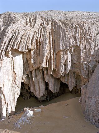
In 1193 Saladin died peacefully in Damascus. After his death, his dominions split up into a loose dynastic empire controlled by members of his family, the Ayyubids. Within this empire, the Ayyubid sultans of Egypt were paramount because their control of a rich, well-defined territory gave them a secure basis of power. Economically, the Ayyubid period was one of growth and prosperity. Italian, French, and Catalan merchants operated in ports under Ayyubid control. Egyptian products, including alum, for which there was a great demand, were exported to Europe. Egypt also profited from the transit trade from the East. Like the Fatimids before him, Saladin brought Yemen under his control, thus securing both ends of the Red Sea and an important commercial and strategic advantage.
Culturally, too, the Ayyubid period was one of great activity. Egypt became a center of Arab scholarship and literature and, along with Syria, acquired a cultural primacy that it has retained through the modern period. The prosperity of the cities, the patronage of the Ayyubid princes, and the Sunni revival made the Ayyubid period a cultural high point in Egyptian and Arab history.
Egypt geology
The Mamluks, 1250-1517
To understand the history of Egypt during the later Middle Ages, it is necessary to consider two major events in the eastern Arab World: the migration of Turkish tribes during the Abbasid Caliphate and their eventual domination of it, and the Mongol invasion. Turkish tribes began moving west from the Eurasian steppes in the sixth century. As the Abbasid Empire weakened, Turkish tribes began to cross the frontier in search of pasturage. The Turks converted to Islam within a few decades after entering the Middle East. The Turks also entered the Middle East as mamluks (slaves) employed in the armies of Arab rulers. Mamluks, although slaves, were usually paid, sometimes handsomely, for their services.
Indeed, a mamluk’s service as a soldier and member of an elite unit or as an imperial guard was an enviable first step in a career that opened to him the possibility of occupying the highest offices in the state.
Mamluk training was not restricted to military matters and often included languages and literary and administrative skills to enable the mamluks to occupy administrative posts.
In the late tenth century, a new wave of Turks entered the empire as free warriors and conquerors. One group occupied Baghdad, took control of the central government, and reduced the Abbasid caliphs to puppets. The other moved west into Anatolia, which it conquered from a weakened Byzantine Empire.
The Mamluks had already established themselves in Egypt and were able to establish their own empire because the Mongols destroyed the Abbasid caliphate.
In 1258 the Mongol invaders put to death the last Abbasid caliph in Baghdad. The following year, a Mongol army of as many as 120,000 men commanded by Hulagu Khan crossed the Euphrates and entered Syria.
Meanwhile, in Egypt the last Ayyubid sultan had died in 1250, and political control of the state had passed to the Mamluk guards whose generals seized the sultanate. In 1258, soon after the news of the Mongol entry into Syria had reached Egypt, the Turkish Mamluk Qutuz declared himself sultan and organized the successful military resistance to the Mongol advance. The decisive battle was fought in 1260 at Ayn Jalut in Palestine, where Qutuz’s forces defeated the Mongol army.
An important role in the fighting was played by Baybars I, who shortly afterwards assassinated Qutuz and was chosen sultan. Baybars I (1260-77) was the real founder of the Mamluk Empire. He came from the elite corps of Turkish Mamluks, the Bahriyyah, socalled because they were garrisoned on the island of Rawdah on the Nile River Egypt geology. Baybars I established his rule firmly in Syria, forcing the Mongols back to their Iraqi territories.
At the end of the fourteenth century, power passed from the original Turkish elite, the Bahriyyah Mamluks, to Circassians, whom the Turkish Mamluk sultans had in their turn recruited as slave soldiers. Between 1260 and 1517, Mamluk sultans of TurcoCircassian origin ruled an empire that stretched from Egypt to Syria and included the holy cities of Mecca and Medina.
As “shadow caliphs,” the Mamluk sultans organized the yearly pilgrimages to Mecca. Because of Mamluk power, the western Islamic world was shielded from the threat of the Mongols.
The great cities, especially Cairo, the Mamluk capital, grew in prestige. By the fourteenth century, Cairo had become the preeminent religious center of the Muslim world.
EGYPT UNDER THE OTTOMAN EMPIRE
In 1517 the Ottoman sultan Selim I (1512-20), known as Selim the Grim, conquered Egypt, defeating the Mamluk forces at Ar Raydaniyah, immediately outside Cairo. The origins of the Ottoman Empire go back to the Turkish-speaking tribes who crossed the frontier into Arab lands beginning in the tenth century. These Turkish tribes established themselves in Baghdad and Anatolia, but they were destroyed by the Mongols in the thirteenth century.
In the wake of the Mongol invasion, petty Turkish dynasties called amirates were formed in Anatolia. The leader of one of those dynasties was Osman (1280-1324), the founder of the Ottoman Empire.
In the thirteenth century, his amirate was one of many; by the sixteenth century, the amirate had become an empire, one of the largest and longest lived in world history.
By the fourteenth century, the Ottomans already had a substantial empire in Eastern Europe.
In 1453 they conquered Constantinople, the Byzantine capital, which became the Ottoman capital and was renamed Istanbul. Between 1512 and 1520, the Ottomans added the Arab provinces, including Egypt, to their empire.
In Egypt the victorious Selim I left behind one of his most trusted collaborators, Khair Bey, as the ruler of Egypt.
Khair Bey ruled as the sultan’s vassal, not as a provincial governor. He kept his court in the citadel, the ancient residence of the rulers of Egypt.
Although Selim I did away with the Mamluk sultanate, neither he nor his successors succeeded in extinguishing Mamluk power and influence in Egypt.
Only in the first century of Ottoman rule was the governor of Egypt able to perform his tasks without the interference of the Mamluk beys (bey was the highest rank among the Mamluks). During the latter decades of the sixteenth century and the early seventeenth century, a series of revolts by various elements of the garrison troops occurred. During these years, there was also a revival within the Mamluk military structure. By the middle of the seventeenth century, political supremacy had passed to the beys.
As the historian Daniel Crecelius has written, from that point on the history of Ottoman Egypt geology can be explained as the struggle between the Ottomans and the Mamluks for control of the administration and, hence, the revenues of Egypt, and the competition among rival Mamluk houses for control of the beylicate.
This struggle affected Egyptian history until the late eighteenth century when one Mamluk bey gained an unprecedented control over the military and political structures and ousted the Ottoman governor.
